Showing posts with label Transit. Show all posts
Sunday, May 9, 2010
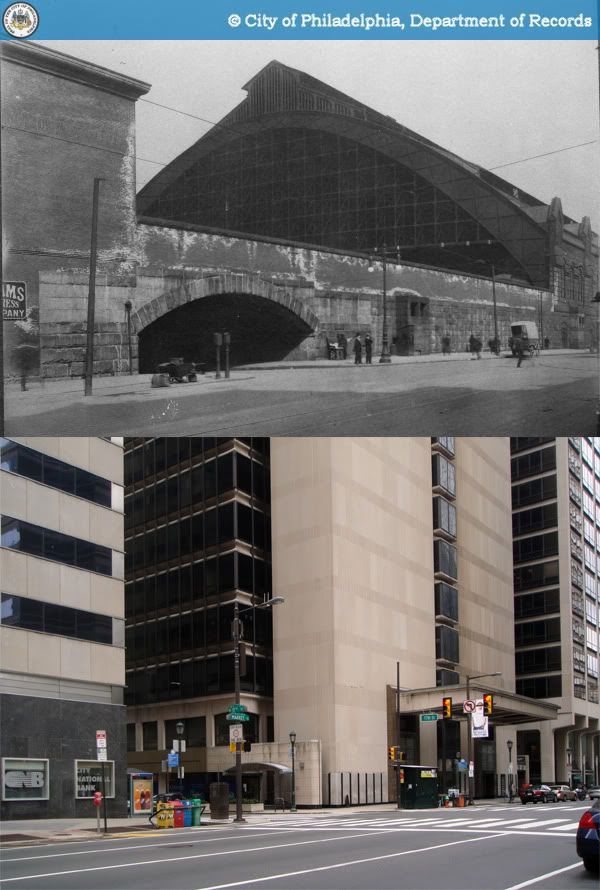
Then and Now: Baltimore & Ohio Railroad station, 24th and Chestnut Streets, Philadelphia
The Baltimore & Ohio Railroad entered Philadelphia's rapidly-growing passenger rail market in the late-19th century, opening its own passenger terminal in 1888 at 24th and Chestnut Streets, at the foot of the Chestnut Street Bridge. The station was designed by none other than the prolific Furness, Evans, & Co., who went on the build the much grander expansion to Broad Street Station just a few years later. Perhaps owing to the station's less than ideal location and relatively minuscule size, it never quite achieved the landmark status attained by the city's other two Center City terminals, Broad Street Station and Reading Terminal.
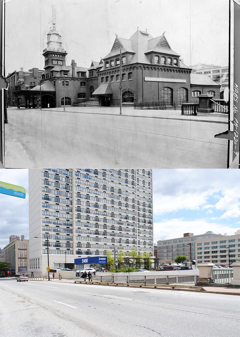
Passenger service ended along the Baltimore & Ohio line in the late 1950s, and the Philadelphia station was demolished in 1963. The building's former site stood vacant for over a decade before the completion of a 34-story apartment tower, 2400 Chestnut, in 1979. Through a number of acquisitions and mergers, the remnants of the B&O are now part of CSX Transportation, a freight company which continues to operate the railroad's tracks along the Schuylkill.
Some more tidbits on 2400 Chestnut [Philly Skyline]
Sources:
1. "2400 Chestnut Apartments, Philadelphia, U.S.A." Emporis.com. 8 May 2010. http://www.emporis.com/application/?nav=building&lng=3&id=2400chestnutapartments-philadelphia-pa-usa.
2. Philadelphia Architects and Buildings
Original photos:
1. "PA-1220-7 - Photocopy of photograph: Perspective view of north and east elevations." Historic American Buildings Survey. American Memory. Library of Congress. 8 May 2010. http://memory.loc.gov/pnp/habshaer/pa/pa1000/pa1097/photos/138632pv.jpg.
2. "PA-1220-9 - View from north west, closeup of station." Historic American Buildings Survey. American Memory. Library of Congress. 8 May 2010. http://memory.loc.gov/pnp/habshaer/pa/pa1000/pa1097/photos/138634pv.jpg.
Saturday, September 12, 2009
Then and Now: Northeast corner of 17th and Market Streets, Philadelphia
This is a street level view of what was formerly Broad Street Station's viaduct and massive train shed north of Market Street, now part of Penn Center. Though it definitely lacks activity outside of the workday, it remains a functional downtown district that seamlessly connects with its adjacent neighborhoods. In that respect, Philadelphia fared much better than many other cities which lost their train stations to decidedly very lackluster replacements.
For the most part, the Penn Center area is one massive showroom for the works of Vincent G. Kling & Associates. Though Kling never obtained the same international notoriety and acclaim as fellow Philadelphian architects Louis Kahn and Robert Venturi, no firm proved to be nearly as influential as his own in shaping Philadelphia's modern downtown thanks to a privileged relationship with the city's Planning Commission. Kling was behind Seven Penn Center, pictured in the center, Five Penn Center behind it, as well as the iconic Centre Square complex and the Municipal Services Building.
Original photo: "City Archives-828-0." 1912. Philadelphia City Archives. PhillyHistory.org. Philadelphia Department of Records. 7 Sep. 2009. http://www.phillyhistory.org/PhotoArchive/MediaStream.ashx?mediaId=55229
Monday, August 3, 2009
What's in a bus stop?
Here in Philadelphia, SEPTA runs a very extensive bus network that (at least on weekdays) provides good and frequent service on most city routes. This is probably one of the city's most well-guarded secrets. For just about anyone who's never needed to get somewhere by bus, the whole thing's an enormous, inscrutable mystery. In many ways, it comes down to a simple problem of signage.
SEPTA's bus stops aren't actually invisible, but to transit newbies, they might as well be. The vast majority of their stops are marked by small signs attached to light or power poles, easily lost among other messy streetscape elements. But that's really the least of our problems. The signs themselves provide minimal descriptions of route endpoints and major roads taken, but even if one is familiar enough with the city's geography to know where those are, most routes tend to wind around quite a bit, so it's really not saying very much. There's a customer service number you could call, or you could wait for the bus and ask the driver, but who really wants to bother with that?
Of course it doesn't need to be this way. There are lots of transit agencies out there that have their bus stops very well thought out, perhaps none more so than Paris. Each stop with a bus shelter (most of them) is equipped with route maps, system maps, a neighborhood map, and a nifty electronic screen that displays waiting times for each route.


Unfortunately, this costs a lot of money, something which SEPTA and most US transit agencies have historically been short on. But an effective and informative system can still be devised on a more restricted budget. For an indication of how much information can be packed into small signs, Taipei provides a sharp example. Each bus signpost has a basic map listing all stops, transfers to rail services, off-peak and peak hour frequencies, and first and last bus times.
It's already miles ahead of what SEPTA provides - to get any of that kind of information most of us just have to spend our time fumbling through route maps online or in stations. Attracting more people to transit is one of the most important challenges of the 21st century, and all forms of transit should be made as easily navigable as possible to draw new ridership. The biggest hurdle in learning a bus system is finding bus stops, routes, and where they connect. Unfortunately, SEPTA makes this about as hard as it could be. Putting aside notions of social stigma that surrounds taking the bus, is it any wonder that buses have few casual riders given how inaccessible the system is? If SEPTA really wants to be a world class transit network the city deserves, this isn't going to cut it anymore.
SEPTA's bus stops aren't actually invisible, but to transit newbies, they might as well be. The vast majority of their stops are marked by small signs attached to light or power poles, easily lost among other messy streetscape elements. But that's really the least of our problems. The signs themselves provide minimal descriptions of route endpoints and major roads taken, but even if one is familiar enough with the city's geography to know where those are, most routes tend to wind around quite a bit, so it's really not saying very much. There's a customer service number you could call, or you could wait for the bus and ask the driver, but who really wants to bother with that?
Friday, February 27, 2009
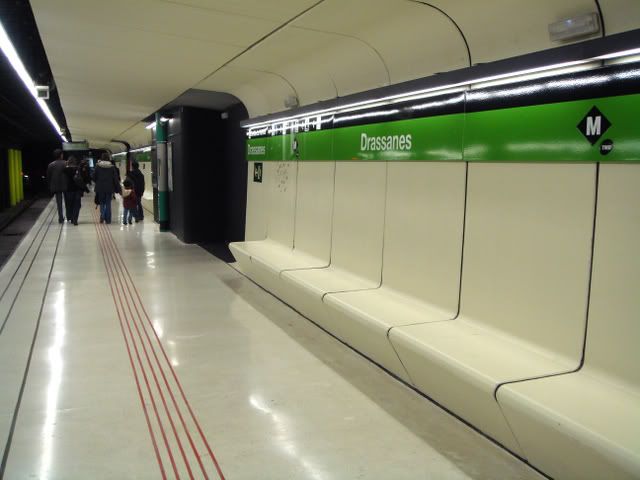
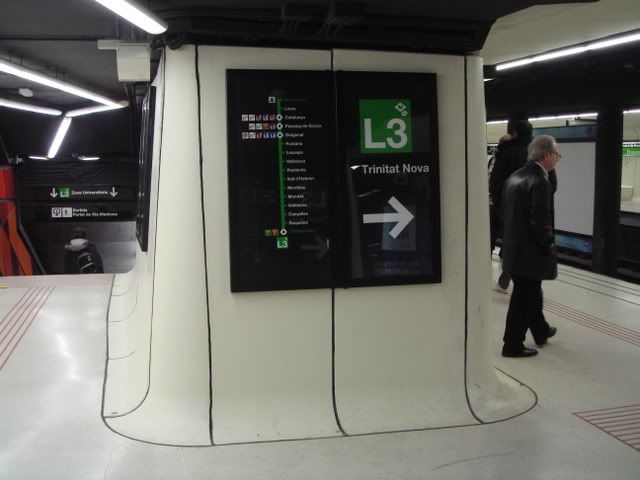
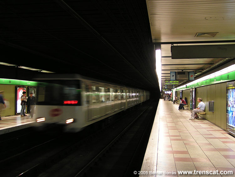
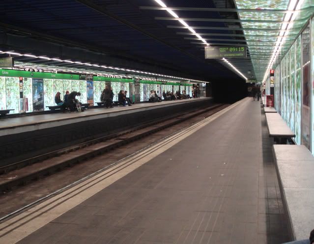
Renovations in el Metro de Barcelona
SEPTA outlines projects set for federal funds [Philadelphia Inquirer]
Note: Subway line lengths roughly calculated on Wikipedia
Wednesday, December 31, 2008
Nangang Metro Station (南港捷運站)
Monday, December 15, 2008
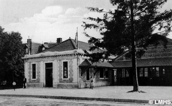
Then and Now: the Ardmore Trolley and Llanerch Railway Station, Ardmore
Though Philadelphia's Main Line suburbs came to existence thanks largely to the efforts of the mighty Pennsylvania Railroad, it was not long before the city's rapidly growing streetcar and trolley network made its way into Delaware and Montgomery Counties. The Philadelphia and West Chester Traction Company (later known as the Philadelphia Suburban Transit Company) first brought surburban trolley service to Llanerch and south Ardmore in 1902. Service was extended to Lancaster Pike three years later with the opening of the Ardmore trolley terminal, a short walk from the Pennsylvania Railroad's Ardmore Station.
Unfortunately, trolley service between downtown Ardmore and West Philadelphia did not survive America's postwar public transportation crisis. The Philadelphia Surburban Transit Company ended service to Ardmore in 1966, and the trolley station and tracks were demolished and replaced by a pocket park and (of course) an adjoining parking lot. The pocket park has subsequently been renamed Schauffele Plaza, and underwent a facelift several years ago as part of Ardmore's streetscape improvement project. It the only public park and seating area downtown, and is a stop for several SEPTA bus routes. Three of the PSTC's more fortunate suburban trolley lines are still operated today by SEPTA - routes 101, 102, and the 100 high-speed line.
Source: "Montgomery County: The Second Hundred Years - 1983." Lowermerionhistory.org. 15 Dec. 2008. http://www.lowermerionhistory.org/texts/first200/transportation_6.html
Original Image: "Ardmore Trolley and Llanarch Railway Stations, Ardmore." c. 1910. Lower Merion Historical Society Archives. Lowermerionhistory.org. Lower Merion Historical Society. 10 Dec. 2008. http://www.lowermerionhistory.org/photodb/full/115-4.jpg
Unfortunately, trolley service between downtown Ardmore and West Philadelphia did not survive America's postwar public transportation crisis. The Philadelphia Surburban Transit Company ended service to Ardmore in 1966, and the trolley station and tracks were demolished and replaced by a pocket park and (of course) an adjoining parking lot. The pocket park has subsequently been renamed Schauffele Plaza, and underwent a facelift several years ago as part of Ardmore's streetscape improvement project. It the only public park and seating area downtown, and is a stop for several SEPTA bus routes. Three of the PSTC's more fortunate suburban trolley lines are still operated today by SEPTA - routes 101, 102, and the 100 high-speed line.
Source: "Montgomery County: The Second Hundred Years - 1983." Lowermerionhistory.org. 15 Dec. 2008. http://www.lowermerionhistory.org/texts/first200/transportation_6.html
Original Image: "Ardmore Trolley and Llanarch Railway Stations, Ardmore." c. 1910. Lower Merion Historical Society Archives. Lowermerionhistory.org. Lower Merion Historical Society. 10 Dec. 2008. http://www.lowermerionhistory.org/photodb/full/115-4.jpg
Thursday, November 6, 2008
New transit signs for Center City
I'm guessing that full implementation will not be until next year, and that the current design could be tweaked before then, but I have to say that at the moment these new signs are an unfortunate disappointment coming from the CCD, surely one of Philadelphia's most progressive and successful de facto city planning agencies.
The potential here is enormous. Though SEPTA has made an impressive turnaround in the region this year partly thanks to rising gas prices, it has a long way to go in shedding its dowdy and outdated image. Sure it desperately needs to improve service and physically fix up the decrepit Broad Street Line and underground trolley stops, but I wouldn't at all underestimate the wonders that good, distinct design and signage can do for how tourists and citizens alike perceive SEPTA. There are precious few world-class transit networks in the world that do not have well-designed wayfinding and signage systems. Need an example?
Not saying that producing a sign like that would be practical today, but many great transit systems like those in Paris, London, Hong Kong, or Boston here in the States have distinct signage systems that contribute greatly to the experiences of their users. Clearly, this is was one of the motivations behind the project, taken from PATCO's press release:
"Great cities have great transit systems made memorable by their visibility, clarity of signage and direction, and ease of use," added Meryl Levitz, president and CEO of the Greater Philadelphia Tourism Marketing Corporation. "Philadelphia has an extraordinary opportunity to transform its transit system into one of the finest and friendliest in the world and implementation of this transit sign project represents a "significant step in that direction."Yet I fear that the transit signs that went up last week fall far too short of that goal. It's true that green is all the rage these days but it's not a very striking color. I'm no design expert but the signs don't strike me as being bold enough or clear enough. If you've got an opinion on these definitely take the survey on the CCD's website. Let's hope that the final product will be a lot better as a result.
Subscribe to:
Posts (Atom)