Monday, October 26, 2009

Then and Now: West side of 8th Street north of Bainbridge Street, Philadelphia

1969-2009

Though most of South Philadelphia avoided the rampant destruction and abandonment that plagued other parts of the city, its historic building stock nonetheless suffered from its fair share of neglect and insensitive facade alterations. Built in the early 1880s, the Church of the Crucifixion has had its original Gothic Revival facade marred by the replacement of its arched windows with horizontal windows quite out of character with its design. Its neighbors on the northwest corner of 8th and Bainbridge Streets lost much of their elegance along with their storefronts.

Remnants of a bygone time, two of 8th Street's former trolley wire poles still stand at the intersection, currently serving as particularly tall signposts.

Source: Philadelphia Architects and Buildings
Original photo: "Historic Commission-12159-15." 1969. Philadelphia City Archives. PhillyHistory.org. Philadelphia Department of Records. 9 Sep. 2009. http://www.phillyhistory.org/PhotoArchive/MediaStream.ashx?mediaId=144357.

Tuesday, October 13, 2009

Then and Now: Southeast corner of 9th and Market Streets, Philadelphia

c. 1900 - 2009

Perhaps no episode in the sad decline of Market East is as scarring as the disintegration of the Gimbel Brothers Department Store. Though not a home-grown institution like its many competitors (Strawbridge's, Wanamaker's, Lit Brothers, etc.) the store became a dominant landmark along Market Street. At its height, the Gimbels empire occupied the entire block of Market Street between 8th and 9th Streets, as well as a 12-story office and warehouse building on Chestnut Street. The building at the corner of 9th Street was designed by Addison Hutton in 1896 and originally built for Cooper & Conard, but quickly taken over by Gimbels. Its distinctive curved corner and arched facade are hauntingly memorable, adding to the surreal, ghostly quality of the original image.

In the 1970s, Gimbels became involved in plans for The Gallery at Market East as one of its main prospective tenants. Upon the completion of The Gallery I in 1977, Gimbels relocated its downtown flagship store to a plain concrete box at 10th and Market, abandoning its original complex one block to the east. Its former home was demolished shortly afterwards with the exception of its office tower at 833 Chestnut Street by Graham, Anderson, Probst, and White, though this is little consolation.

Barely a decade after the move, the Gimbels chain collapsed and its properties were sold. Its location in the Gallery is now occupied by a KMart store. The 800 block of Market Street, three decades after its demolition, remains an enormous vacant lot with little development prospect.

Sources:
1. Philadelphia Architects and Buildings
2. Fischer, John. "Gone but not forgotte - Gimbel's, Lit Brothers, Strawbridge & Clothier, and Wanamaker's Department Stores." About.com. 12 Oct. 2009. http://philadelphia.about.com/od/history/a/strawbridges.htm.
Original photo: "Department of City Transit-41118-0." Philadelphia City Archives. PhillyHistory.org. Philadelphia Department of Records. 12 Oct. 2009. http://www.phillyhistory.org/PhotoArchive/MediaStream.ashx?mediaId=52491.

Thursday, October 8, 2009

Then and Now: 5 East Lancaster Avenue, Ardmore

Date unknown-2009

Oddly enough, the squat stucco building at the corner of Lancaster and Anderson Avenues is in fact one of downtown Ardmore's oldest commercial buildings. The Merion Title & Trust Company built its first Ardmore office in 1897 before relocating in 1917 to a new classical revival edifice built adjacent to its former home. The original structure at the heart of town also housed a variety of tenants over the years, including a Post Office, library, and Western Union station. In 1977, all but the bottom two floors of the building were tragically destroyed in a fire, and were subsequently remodeled in a coat of stucco. Would it still merit preservation at this point? Perhaps the question will come up someday, if the logic of suburban development once again turns its eye to Ardmore's main street.

Source: Lower Merion Township: Searchable HR Database. Lower Merion Township Historical Commission. 30 Sep. 2009.
Original photo: "Ardmore Post Office Building." Lower Merion Historical Society Archives. Lowermerionhistory.org. Lower Merion Historical Society. 28 Sep. 2009.
http://www.lowermerion.org/Index.aspx?page=437

Tuesday, October 6, 2009

Then and Now: 16th and Sansom Streets looking west, Philadelphia

1969-2009

The 1600 block was not spared the gradual 20th century conversion of Sansom Street to a de facto service street dominated by parking garages and loading areas. This handsome commercial row on the 1601 block managed to survive until 2000, when it fell victim to one of the greatest crimes against historic preservation in Philadelphia's recent history, senselessly cleared to make way for a 12-story parking garage which never materialized. To make matters bitterly ironic, the developer, Wayne Spilove, was also serving as chairman of the Historical Commission at the time.

Original photo: "Department of City Transit-39825-0." 1969. Philadelphia City Archives. PhillyHistory.org. Philadelphia Department of Records. 2 Oct. 2009. http://www.phillyhistory.org/PhotoArchive/MediaStream.ashx?mediaId=52405

Friday, October 2, 2009

Then and Now: 16th and Sansom Streets looking east, Philadelphia

1969-2009

Hemmed in by towers and skyscrapers, the south side of the 1500 block of Sansom Street contains a row of narrow 2- and 3-story buildings housing a motley crew of small locally-owned shops, bars, and restaurants that feel far removed from their surrouding streets. By and large, these businesses would be unsuitable for the larger floor spaces or higher rents on Chestnut Street or Walnut Street, dominated for the most part by national and international retail chains. Sansom Street's shops add an invaluable contribution to the Rittenhouse area's retail mix and hence to its liveliness. It's Jane Jacobs' theory of diversity in action: a variety of building types and ages are a natural generator of activity.

Original photo: "Historic Commission-12827-37." 1969. Philadelphia City Archives. PhillyHistory.org. Philadelphia Department of Records. 21 Sep. 2009. http://www.phillyhistory.org/PhotoArchive/MediaStream.ashx?mediaId=152807

Tuesday, September 29, 2009

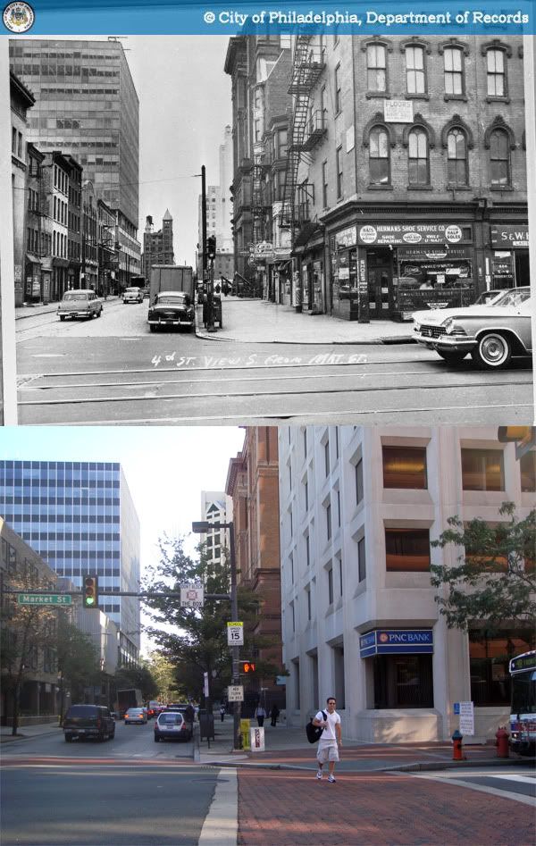
Then and Now: 4th and Market Streets looking south, Philadelphia

1959-2009

As the result of the gradual replacement of older buildings with poorly-designed new additions with minimal ground-floor retail presence, 4th Street suffers from an excess of blank walls and the typically moribund street life that plagues Old City's western edge. The boxy Continental Building (1970) on the southwest corner of 4th and Market is just about as bland as Modernism could ever get. I'm not sure when the WTXF/Fox 29 building was built across 4th street, yet its deadening effect upon the street wall is equally regrettable.

Original photo: "Department of City Transit-39516-0." 1959. Philadelphia City Archives. PhillyHistory.org. Philadelphia Department of Records. 2 Sep. 2009. http://www.phillyhistory.org/PhotoArchive/MediaStream.ashx?mediaId=33335.

Saturday, September 26, 2009

Jacques Gréber's 1917 Plan for Philadelphia

(enlarge for detail)

In 1917, with the Fairmount Parkway finally taking shape after years of planning, stalling, and demolition, the Fairmount Park Commission commissionned 34-year-old French architect and planner Jacques Gréber to prepare the final plans for the Parkway's layout and building siting. So it was likely with great confidence that he returned to Philadelphia from his Paris office later that year with his plans and sketches for the boulevard. Tucked among those was another plan, pictured here, showing a vision for all of central Philadelphia featuring a new set of radial avenues presumably of Gréber's invention.

Having secured a commission as prestigious as the Parkway at a relatively young age, the ambitious Gréber likely fancied himself a bit as Philadelphia's 20th century Baron Haussmann. Somewhat unsurprisingly, his plan of axial streets linking a series of traffic circles, parks, and squares is quite reminiscent of the 1792 plan for Washington by Pierre Charles L'Enfant, the most renown French-American planner. I don't know how seriously Gréber expected his drawing to be received, and it certainly never gained much traction as an official planning document, yet it remains a particularly striking image to anyone with more than a passing knowledge of Philadelphia's street grid.

Interestingly, Gréber incorporated or extended the city's existing oblique streets into his network of new radial avenues. One of the more significant components of the plan was to extend Franklin Square two blocks to the west to meet Ridge Avenue at a new traffic circle à la Logan Circle to the west. "Franklin Circle" would also intersect with a new axis running from Reading Terminal at 11th and Market through Northern Liberties to a large park at Front and Germantown. Grays Ferry Avenue was extended to Rittenhouse Square, and Passyunk Avenue to a riverfront plaza at Front and Market.

Despite the many fanciful components of Gréber's vision like traffic circles at Broad and Fairmount and at 24th and Market, portions of it did curiously enough take shape under the auspices of future planners who had likely never seen this plan of his. Before becoming a sunken expressway, Vine Street was widened in the late 40s. The idea for a great plaza where Market Street meets the Delaware River would later be realized somewhat in the form of Penn's Landing. Gréber also pictured a reclaimed, park-like lower Schuylkill riverfront, which was at the time a mass of industrial buildings and rail yards around a tide of fetid waste. It was not until over 90 years later, after decades of wrangling and planning, that the Schuylkill Banks park as we know it began to take shape.

Image source: Gréber, Jacques. "Partial plan of the city shewing its new civic centre and the connexion of the Fairmount Parkway with the present street system & other proposed radial avenues." Drawing. Fairmount Park Art Association. The Fairmount Parkway. Philadelphia: Fairmount Park Art Association, 1919.