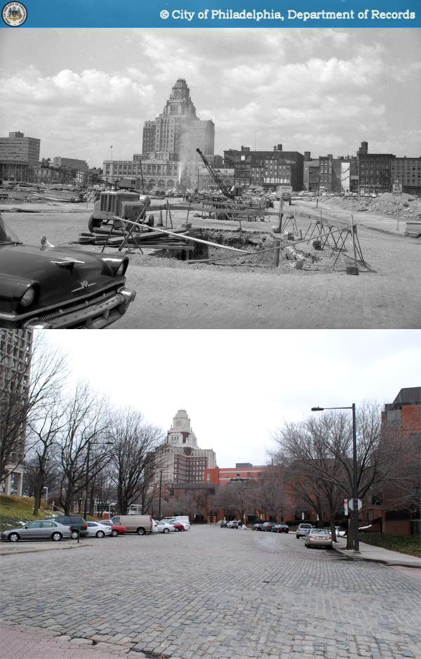
1962-2010
(continued from previous post)
Dock Street's 100 block was rebuilt in two phases after its demolition. The rubble had barely cleared when the I. M. Pei-designed Society Hill Towers (1964) began to rise, set back from the street on an artificial hill. The triangular lot on the opposite side of Dock Street remained a surface parking lot for two decades before the opening of the Sheraton Society Hill Hotel in 1986, developed by regional mega-developer Willard Rouse.
Modernist urban renewal wasn't particularly keen on complexity or historical context. In their eagerness to "preserve" Society Hill as a refined, leafy, residential neighborhood, city planners chose to honor one peculiar vision of the colonial city that was oddly enough devoid of any serious commercial activity. Perhaps it was due to a bitter recognition that Philadelphia's time as a manufacturing powerhouse was over that the city's urban renewal efforts seemed particularly intent on eliminating all traces of the city's mercantile and industrial heritage. The photograph below, taken in 1961 from Front and Spruce Streets, gives a pretty good idea of the enormous amount of demolition needed to build Society Hill as we know it today.
 Thankfully, city planning and historic preservation have greatly evolved in the last few decades, and indiscriminate, large-scale demolition is hardly in vogue nowadays. Faced with similar circumstances, there is little doubt that today's planners would certainly not make the same kinds of decisions as those of their predecessors. Philadelphians and their leaders now take great pride in billing their city as the former "workshop of the world."
Which probably makes Dock Street's fate all the more unfortunate. Its great width once made it a critical transfer point for goods coming into the port of Philadelphia. Now severed from the Delaware River by I-95, having lost all of its former street wall, today's Dock Street has also lost much of its reason for being. Unknowing visitors who now stroll along its wide, curving, Belgian block path could be easily forgiven for their bewilderment as to why it exists, seemingly outside of any meaningful context. If they were shown a few pre-war photographs, they could also be forgiven for their shock and disbelief.
Source: Bymes, Gregory R. "Rouse planning more hotels in Center City." Philadelphia Inquirer. 4 Dec. 1985: E01.
Photographs:
1. Widdop. "Historic Commission-47668-0." 1962. Philadelphia City Archives. Phillyhistory.org. Philadelphia Department of Records. 27 Feb. 2010. http://www.phillyhistory.org/PhotoArchive/MediaStream.ashx?mediaId=107111.
2. Widdop. "Historic Commission-44551-0." 1961. Philadelphia City Archives. Phillyhistory.org. Philadelphia Department of Records. 27 Feb. 2010. http://www.phillyhistory.org/PhotoArchive/MediaStream.ashx?mediaId=10573.
No comments:
Post a Comment