Sunday, January 3, 2010

City Hall Tower views Then and Now, Los Angeles edition

1951-2009
(photo credits: Associated Press and Scott Harrison)


Seeing as the six Philadelphia City Hall tower posts from this past fall have proved fairly popular, I thought I'd start off the new year with a related link - an LA Times interactive feature which pairs six 1951 photographs from Los Angeles City Hall tower with new photographs taken nearly 50 years later.

The pictures reveal some of the striking large-scale transformations that have taken place in downtown LA, including the obliteration and reconstruction of Bunker Hill and the emergence of the Civic Center complex. Thanks to the relatively large image size of the carefully alignmed photographs, one can even spot plenty of changes on the level of individual blocks and buildings, including the replacement of entire blocks by single structures and the encroachment of surface parking. It's quite fascinating, even with little familiarity with the sprawling West Coast metropolis. Major kudos to the LA Times and photographer Scott Harrison.

Posting has been light as of late due to a busy end of the year and holiday season. Look forward to more content soon in 2010. Happy new year!

More mid-20th century photographs of Los Angeles [Skyscraperpage Forum]

Sunday, December 27, 2009

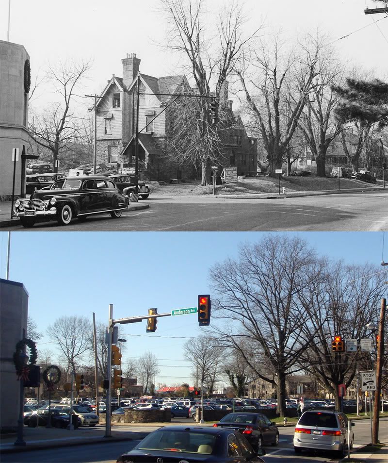
Then and Now: Southwest corner of Montgomery and Anderson Avenues, Ardmore

1940 - 2009

The corner of Montgomery and Anderson Avenues was once the estate of one of Lower Merion Township's most prominent residents, Dr. George S. Gerhard, founder of Bryn Mawr Hospital. Built in the 1880s, the house was converted in the early 1920s into a residence hall for the newly consolidated Main Line YMCA, whose main building was then on Lancaster Avenue. Likely due to budget issues resulting from this arrangement, the Gerhard house was demolished and sold in early 1941. The YMCA reopened in 1956 in a new main facility across Montgomery Avenue, still used today. The former Gerhard estate has spent the last half-century as a parking lot for Suburban Square customers, sometimes referred to as "the Ruby's lot."

In 2008, the shopping center's owner, Kimco Realty, proposed replacing the lot with a mixed-use condominium complex. That suggestion was ultimately withdrawn following what seemed to be widespread opposition among nearby residents. Aside from standard concerns about height, scale, and traffic, one of their principle arguments was that development of the lot would jeopardize the planned Ardmore Transit Center. Anyhow, it's safe to say that the parking lot is here to stay for a while.

Sources:
1. Allison, Cheryl. "Abruptly, Ruby's lot plans withdrawn." Main Line Times 11 Dec. 2008.
2. "Lower Merion Atlases." Lower Merion Historical Society. 20 Dec. 2009. http://lowermerionhistory.org/atlas.html.
3. Schmidt, David. "The Main Line's YMCA has filled community needs for 95 years." Lower Merion Historical Society. 20 Dec. 2009. http://www.lowermerionhistory.org/texts/schmidtd/ymca_for_95_years.html.
4. "The first 300: The amazing and rich history of Lower Merion (part 24)." Lower Merion Historical Society. 20 Dec. 2009. http://www.lowermerionhistory.org/texts/first300/part24.html.
Original photo: "2 W. Montgomery Ave." Lower Merion/Narberth Buildings. Lowermerionhistory.org. Lower Merion Historical Society. 20 Dec. 2009. http://lowermerionhistory.org/buildings/image-building-list.php?photo_id=7420.

Tuesday, December 15, 2009

Then and Now: The Mercantile Library, 1021 Chestnut Street, Philadelphia

1962-2009

In 1954, ten years after joining Philadelphia's Free Library system, the Mercantile Library moved to Chestnut Street into a new building designed by local firm Martin, Stewart & Noble. The building immediately won widespread praise among the city's architectural community; Martin, Stewart & Noble were awarded 1954's Gold Medal from the Philadelphia chapter of the American Institute of Architects. Their design was acclaimed for having fulfilled the library's needs within a compact, storefront-sized space, and for its innovative adaptation of commercial design elements. The clean lines of its steel mullions, smooth glass facade, and distinctive signage make it a particularly elegant specimen of postwar Modernism in Philadelphia.

Sadly, after decades of shrinking tax revenues, the City of Philadelphia gradually became incapable of maintaining many of its facilities, including this one. The Mercantile Library shut its doors in 1989 due to a crumbling asbestos problem, and its collections were transferred to the Free Library's main branch on the Parkway. Due to daunting projected repair costs and an enormous maintenance backlog, the city ultimately chose to indefinitely close the library. Though the building was added to the Philadelphia Register of Historic Places in 1990, it has only continued to deteriorate, and substantial plant overgrowth is visible on its roof.

In 2004, the lot was transferred by the city to the Philadelphia Industrial Development Corporation, which subsequently sold it to a private developer. However, the Mercantile Library's fate remains in limbo. There do not seem to be any current plans for its redevelopment, nor any substantial push for its preservation.

Sources:
1. "Fourth Annual Endangered Properties List."
Preservation Matters. Dec. 2007. http://www.preservationalliance.com/files/news/Winter2007.pdf.
2. Wiegand, Ginny. "Library could be put on shelf."
Philadelphia Inquirer. 4 Aug. 1990.
3. Maryniak, Paul. "City's building cup runneth over." Philadelphia Daily News. 26 Feb. 1991.
Original image: Carollo, R. "Historic Commission-49797-0." 1962. Philadelphia City Archives. PhillyHistory.org. Philadelphia Department of Records. 14 Dec. 2009. http://www.phillyhistory.org/PhotoArchive/MediaStream.ashx?mediaId=108087.

Saturday, December 5, 2009

Then and Now: 16th and Ranstead Streets looking southeast, Philadelphia

1936-2009

The two-story office and store building at 1535 Chestnut Street was built in 1936, and originally housed a men's clothing store and steamship company office. Today its ground floor is occupied by a nail salon and Rite Aid pharmacy.

Though not a particularly a particularly ornate building to begin with, it seems that its window panels and facade cladding have been replaced over the years. In 2008, the trees and planters were installed by the Center City District on the somewhat forlorn block to coincide with the opening of the Residences at Two Liberty Place, an office-condo conversion across 16th Street, whose dropoff area is pictured in the current view.

Source: Center City District. "Keeping Center City Green and Lush: CCD Spring Planting." Press Release. 21 Apr. 2008. 5 Dec. 2009. http://www.centercityphila.org/pressroom/prelease042108.php.
Original photo: Gee, William A. "Public Works-35968-0-B." 1936. Philadelphia City Archives. PhillyHistory.org. Philadelphia Department of Records. 16 Sep. 2009.

Monday, November 23, 2009

Then and Now: West Lancaster Avenue viewed from Wyoming Avenue, Ardmore

early 1950s-2009Italic
The original photo shows the north side of Lancaster Avenue viewed from Ardmore's western border in its early days as a suburban strip, almost completely unrecognizable today.

Though not usually considered as such, early 20th century suburban developers were pioneers in adaptive reuse. With a few interior modifications, the the ample setbacks and lawns of former suburban residences were easily paved over to accomodate automobile-oriented commercial uses. Two such houses can be seen in the original view, converted into Tydol and Gulf Oil service stations.

Automobile-related businesses dominated western Lancaster Avenue from the very beginning of the 20th century. The Autocar Company set up shop in 1900 and remained Ardmore's largest employer through the early 1950s. Its factory buildings, destroyed by fire in 1956, are visible in the original photo. Though the Ardmore West strip mall replaced most of the Autocar site, the south side of the avenue remains crowded with car dealerships. Fascinatingly, the especially resilient Sunoco gas station at the corner of Lancaster and Woodside Avenues has been operating there since as early as 1926.

Sources:
1. "The First 300: The Amazing and Rich History of Lower Merion." Lowermerionhistory.org. 21 Nov. 2009. http://lowermerionhistory.org/texts/first300/index.html
2. Bromley, George W. and Walter S. Bromley. Atlas of Properties on Main Line Pennsylvania Railroad from Overbrook to Paoli. Atlas. Philadelphia: G.W. Bromley & Co, 1926.

Original image: "W Lancaster Avenue." 2008. Lower Merion/Narberth Buildings. Lowermerionhistory.org. Lower Merion Historical Society. 15 Nov. 2009. http://lowermerionhistory.org/buildings/image-building-list.php?building_id=407

Monday, November 16, 2009

Then and Now: Southwest corner of Lancaster and Cricket Avenues, Ardmore

c. 1920s - 2009

Built sometime between 1913 and 1920, the nameless 3-story building at the corner of Cricket and Lancaster Avenues has long been one of Ardmore's most distinct buildings. It's a wonderfully detailed specimen of Renaissance Revival design, and given the high quality of craftsmanship evident in its construction, was almost certainly built for relatively wealthy inhabitants. Though merely an apartment building in function, it easily found itself among the town's most postcard-worthy sites during the 1920s.

What's particularly striking about the building's design is how resolutely urban it is. Though most buildings on Lancaster Avenue were built with upper-story apartment space, none of them are nearly as eager in their outward expression of a specific vision of residential life. Here, the abundant bay windows and balconies are strongly suggestive of density and old-school urbanity, out of step with dominant ideals about peaceful, reserved suburban living. It seems to reveal an original developer who had grander ambitions for Ardmore's future, at a time when growth had no foreseeable end.

Today, the building is one of historic Ardmore's greatest assets. Thankfully, despite modifications to its Lancaster Avenue storefronts, the original detailing of its upper stories remains remarkably intact. Unfortunately, two of its ground-floor retail spaces continue to underperform at the hands of a nail salon and spacious ATM cubicle. Needless to say, it really deserves better.

Source: Atlas of Properties on Main Line Pennsylvania Railroad From Overbrook to Paoli. Atlas. Philadelphia: A.H. Mueller, 1920.
Original image: "7 E Lancaster Ave." 2008. Lower Merion/Narberth Buildings. Lowermerionhistory.org. Lower Merion Historical Society. 15 Nov. 2009.

Monday, November 9, 2009

Then and Now: 13th and Sansom Streets looking southwest, Philadelphia

1965-2009

Few visitors to Philadelphia today, standing at the corner of 13th and Sansom, would feel much indication of 13th Street's turbulent recent history beneath its glimmering boutiques and restaurants. Neither, ufortunately, is any of it easily apparent in the above montage.

At the time of the original photo, 13th Street between Chestnut and Locust Streets was a fur district dotted with bars and luncheonettes serving office workers from South Broad Street. By the early 90s, 13th Street had become downtown's skid row and red light district, blamed upon the continuous western movement of Philadelphia's office district. Then, it attracted substantial attention from the press for its new reputation as Center City's most blighted street, a haven for prostitution, and the new center of gay nightlife. Officials decried it as an enormous black hole between the new Convention Center and the Avenue of the Arts theater district.

Remarkably, the area's turnaround is largely attributed to one individual, shrewd New York developer Tony Goldman. In 1998, Goldman Properties began purchasing buildings in the 13th Street area, investing millions into their renovation, and aggressively marketing the district to new retailers. No doubt, that story is overly simplistic, but the changes that have occurred in the decade since then have been nothing less than momentous. Today's 13th Street is one of downtown Philadelphia's liveliest retail corridors, and the proud heart of the city's gay community.

Source: Stoiber, Julie. "'The whole street is popping' - On 13th south of Chestnut, two blocks in a red-light district are turning funky." Philadelphia Inquirer. 3 Apr. 2006. Newsbank Access World News. Haverford College Library, Haverford, PA. 12 Nov. 2009.

Original photo: Carollo, R., and John McWhorter. "Historic Commission-3299-18." 1965. Philadelphia City Archives. PhillyHistory.org. Philadelphia Department of Records. 12 Nov. 2009.