Showing posts with label City Hall Tower. Show all posts
Sunday, January 3, 2010
City Hall Tower views Then and Now, Los Angeles edition
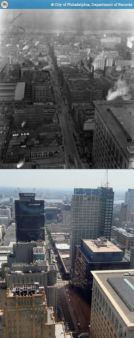
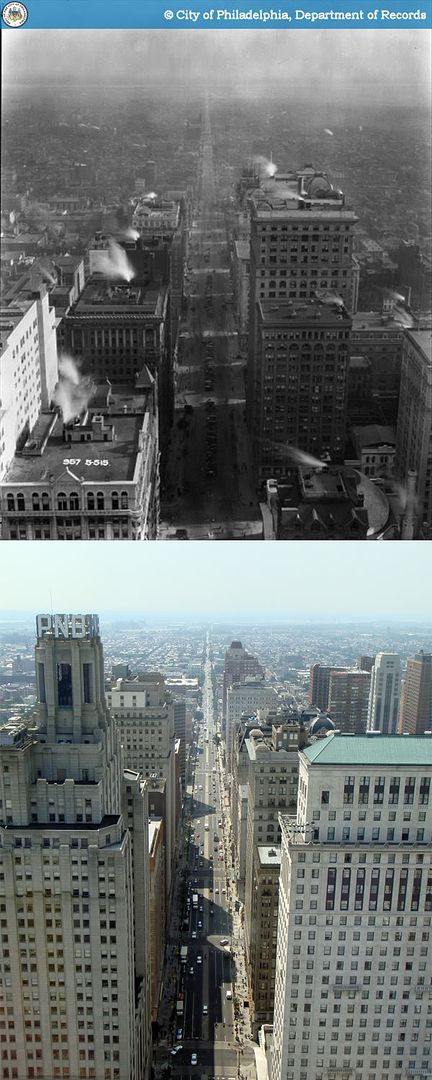
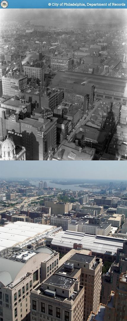
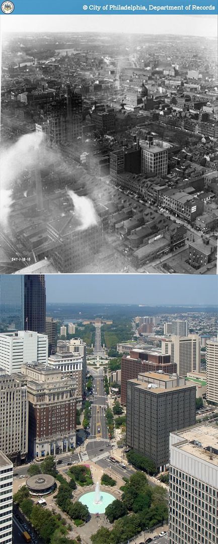
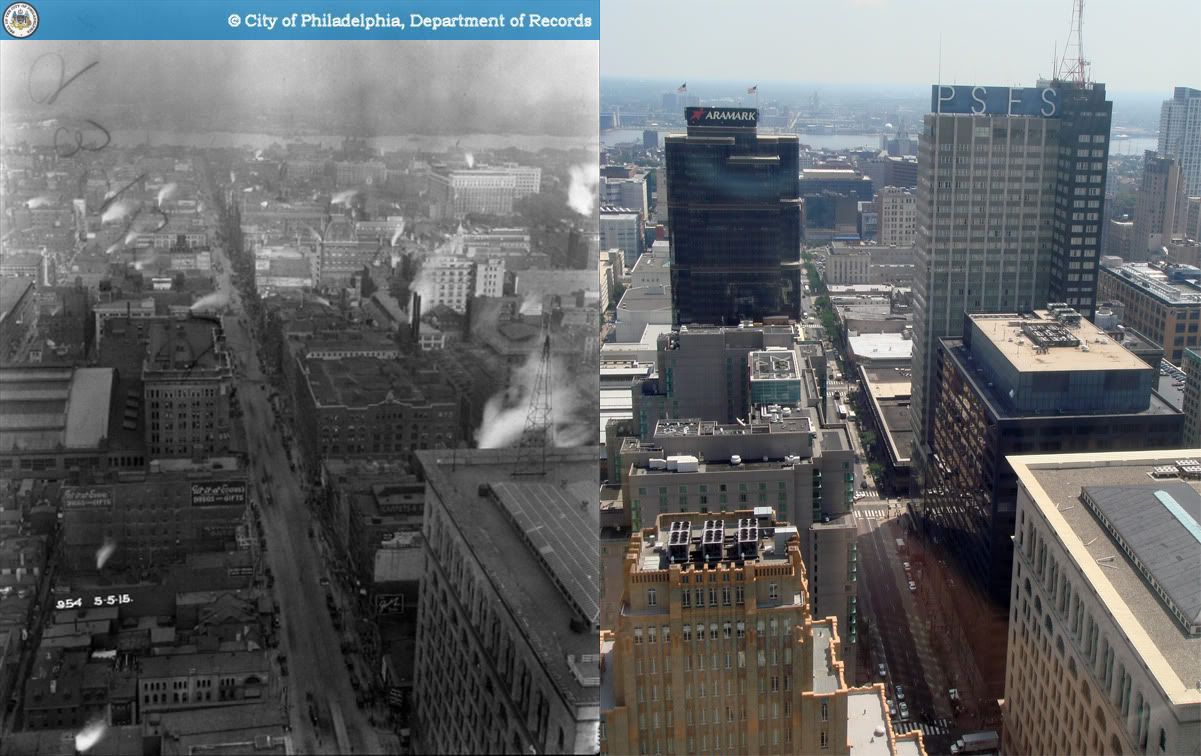
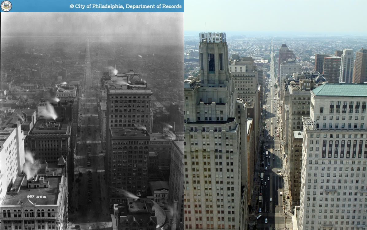
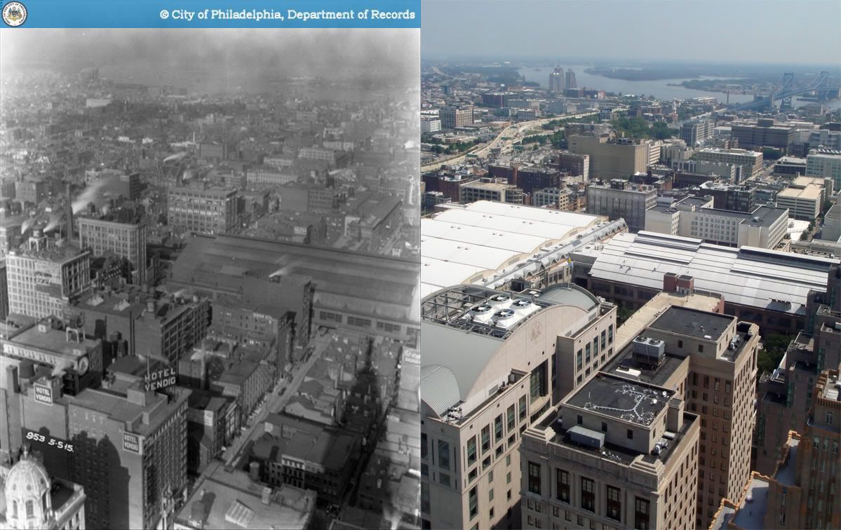
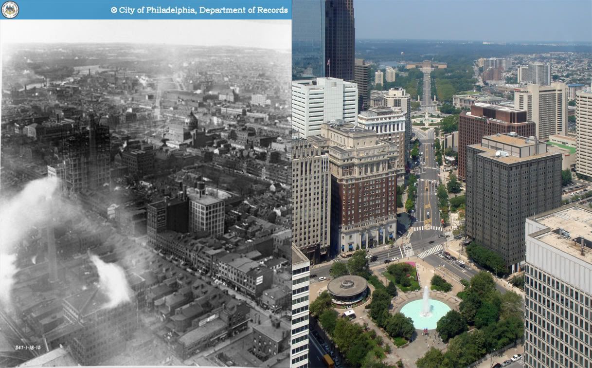
Seeing as the six Philadelphia City Hall tower posts from this past fall have proved fairly popular, I thought I'd start off the new year with a related link - an LA Times interactive feature which pairs six 1951 photographs from Los Angeles City Hall tower with new photographs taken nearly 50 years later.
The pictures reveal some of the striking large-scale transformations that have taken place in downtown LA, including the obliteration and reconstruction of Bunker Hill and the emergence of the Civic Center complex. Thanks to the relatively large image size of the carefully alignmed photographs, one can even spot plenty of changes on the level of individual blocks and buildings, including the replacement of entire blocks by single structures and the encroachment of surface parking. It's quite fascinating, even with little familiarity with the sprawling West Coast metropolis. Major kudos to the LA Times and photographer Scott Harrison.
Posting has been light as of late due to a busy end of the year and holiday season. Look forward to more content soon in 2010. Happy new year!
More mid-20th century photographs of Los Angeles [Skyscraperpage Forum]
Wednesday, September 9, 2009
Then and Now: Northwest Center City viewed from City Hall tower, Philadelphia
In Philadelphia's collective memory, Broad Street Station seems to be best remembered not for the station building itself, but for its massive elevated viaduct which ran along toward Filbert Street toward the Schuylkill River, infamously known as the "Chinese Wall." Indeed, the railroad viaduct posed an enormous physical and economic barrier between Logan Square and the fashionable Rittenhouse Square area south of Market Street. Apart from the completion of the Benjamin Franklin Parkway, Northwest Center City saw relatively little development before 1950s.
After the Pennsylvania Railroad's rerouting of intercity trains to 30th Street Station and commuter rail lines to Suburban Station in the 1930s, Broad Street Station was made nearly obsolete, and its days were numbered. The demolition of the station and its accompanying tracks in 1953 opened a large swath of centrally located, high-value downtown land for redevelopment. In accordance with the city's plans, the corridor was to become a showpiece modern office district of the sort very in vogue among planners at the time. Over 60 years later, the Penn Center/Market West area remains downtown Philadelphia's premier office district.
The area has been so completely transformed that the only major building that survives from the original view is the John T. Windrim-designed Bell Telephone Building at 1613 Arch Street, seen under construction in the original photograph.
Original photo: Rolston, N.M. "Department of City Transit-969-0." 1915. Philadelphia City Archives. PhillyHistory.org. Philadelphia Department of Records. 6 Sep. 2009. http://www.phillyhistory.org/PhotoArchive/MediaStream.ashx?mediaId=18309.
Sunday, September 6, 2009
Then and Now: North Broad Street viewed from City Hall tower, Philadelphia
North Broad Street has always been home to an odd jumble of uses. By the early 20th century, the lower end near City Hall housed a small group of offices and institutional buildings, followed by concentration of large factories and warehouses between Vine and Spring Garden Streets. This general land use pattern remains hardly altered almost a century later, the largest single addition being the growth of Hahnemann University Hospital's campus.
North Broad's newest addition to come is the expansion of the Pennsylvania Convention Center, which will have 1 million square feet of saleable exhibition space upon completion, allowing the already massive building to maintain the distinction of having downtown Philadelphia's largest (and not green) roof.
It's a bit amusing to see the lines of cars parked in the median of Broad Street in the original photo, an odd Philadelphia tradition now confined to South Philadelphia.
A horizontally aligned comparison may be found here.
PCC expansion construction thread [Skyscraperpage]
Original Photo: Rolston, N.M. "Department of City Transit-950-0." 1915. Philadelphia City Archives. PhillyHistory.org. Philadelphia Department of Records. 31 Aug. 2009. http://www.phillyhistory.org/PhotoArchive/MediaStream.ashx?mediaId=18299.
Thursday, August 27, 2009
Then and Now: Market East viewed from City Hall tower, Philadelphia
Though it seems much less gargantuan by today's standards, when John Wanamaker's Department Store (Now Macy's, bottom right corner) opened in 1910, it's grandeur and size were entirely in a league of their own. Designed by Chicago architect Daniel Burnham, at 15 stories and over 270 feet, Wanamaker's was by far the tallest building on Market Street east of City Hall, even dwarfing its closest competition, the Reading Terminal Headhouse.
The other true gem of Market East is of course the International Style masterpiece, the PSFS Building, completed in 1932 with the distinction of being the world's first true modernist skyscraper. It remains one of the finest examples of the International Style in North America.
A horizontally aligned comparison may be found here.
Photographs of the PSFS Building [PhillySkyline]
Source: "Wanamaker Building, Philadelphia." Emporis.com. 27 Aug. 2009. http://www.emporis.com/application/?nav=building&lng=3&id=wanamakerbuilding-philadelphia-pa-usa
Original photo: Rolston, N.M., "Department of City Transit-954-0." 1915. Philadelphia City Archives. PhillyHistory.org. Philadelphia Department of Records. 27 Aug. 2009. http://www.phillyhistory.org/PhotoArchive/MediaStream.ashx?mediaId=18303
Monday, August 24, 2009
Then and Now: South Broad Street viewed from City Hall tower, Philadelphia
At the turn of the 20th century, Broad Street south of City Hall had become Philadelphia's new center of business and finance, and home to the city's first cluster of skyscrapers, long before subsequent growth along Walnut Street west of Broad or the explosive development of Market West and Penn Center. The stretch received several major additions in the 20s and 30s, the most visible including the PNB Building, the Girard Trust Company across the street (now Ritz-Carlton Hotel), and the Fidelity-Philadelphia Trust Company Building (now Wachovia). Having seen few large developments since WWII, to this day South Broad Street retains its classic early 20th-century character.
A horizontally aligned comparison shot can also be found here.
Source: Philadelphia Architects and Buildings
Original photo: Rolston, N.M. "Department of City Transit-957-0." 1915. Philadelphia City Archives. PhillyHistory.org. Philadelphia Department of Records. 24 Aug. 2009. http://www.phillyhistory.org/PhotoArchive/MediaStream.ashx?mediaId=18305
Friday, August 21, 2009
Then and Now: Northeast Center City viewed from City Hall tower, Philadelphia
I'm think the original photographer, a certain N.M. Rolston, would be more than a bit puzzled were he around today to look over Reading Terminal, only to see no railroad viaduct leading out of the trainshed, but a skybridge connecting to an enormously wide (and still growing) Pennsylvania Convention Center exhibition hall. The trains still run today, just underground in the Center City Commuter Tunnel. Much of the seedy landscape of factories, flophouses, and taverns that once dotted this part of downtown disappeared amid new hotels, office towers, and garages. The only area that has conserved much of its old appearance is present-day Chinatown, just east of the Convention Center.
A horizontally aligned comparison shot can also be found here
Original photo: Rolston, N.M. "Department of City Transit-953-0." 1915. Philadelphia City Archives. PhillyHistory.org. Philadelphia Department of Records. 18 Aug. 2009. http://www.phillyhistory.org/PhotoArchive/MediaStream.ashx?mediaId=18301
Tuesday, August 18, 2009
Then and Now: The Parkway viewed from City Hall tower, Philadelphia
One of the true gems to be found on PhillyHistory.org is a small series of photos taken in 1915 from City Hall tower's observation deck. Roughly 500 feet above ground, it remains the city's tallest observation area open to the public, and its location at the heart of Center City lends it the most magnificent view of central Philadelphia.
Although the city has changed significantly in every direction, no view is as radically different as the perspective towards what is now the Benjamin Franklin Parkway. In 1915, the Parkway was barely in its infancy; demolition for the new right-of-way had begun on the site of the former Fairmount Reservoir, and was making its way toward City Hall. The original photograph gives a powerful sense of the sheer enormity of the project, of planners and civic leaders who dreamed of nothing less than the complete reshaping of the American city. This great ambition was on a scale truly befitting a rapidly emerging, daring, and somewhat brash new nation. Indeed, wholesale demolition and reconstruction of existing urban areas these days seems to be the sole province of places like China and Dubai.
The old photograph also provides a quick glimpse of a Logan Square neighborhood which we would not recognize today, one with a rich mix of row houses, factories, and warehouses. Most of that was quickly redeveloped after the creation of the Parkway and the later replacement of Broad Street Station and its railway viaduct in the 50s.
A horizontally aligned comparison shot can also be found here.
Original photo: "Department of City Transit-347-0." 1915. Philadelphia City Archives. PhillyHistory.org. Philadelphia Department of Records. 17 Aug. 2009. http://www.phillyhistory.org/PhotoArchive/MediaStream.ashx?mediaId=56023
Subscribe to:
Posts (Atom)