
(enlarge for detail)
In 1917, with the Fairmount Parkway finally taking shape after years of planning, stalling, and demolition, the Fairmount Park Commission commissionned 34-year-old French architect and planner Jacques Gréber to prepare the final plans for the Parkway's layout and building siting. So it was likely with great confidence that he returned to Philadelphia from his Paris office later that year with his plans and sketches for the boulevard. Tucked among those was another plan, pictured here, showing a vision for all of central Philadelphia featuring a new set of radial avenues presumably of Gréber's invention.
Having secured a commission as prestigious as the Parkway at a relatively young age, the ambitious Gréber likely fancied himself a bit as Philadelphia's 20th century Baron Haussmann. Somewhat unsurprisingly, his plan of axial streets linking a series of traffic circles, parks, and squares is quite reminiscent of the 1792 plan for Washington by Pierre Charles L'Enfant, the most renown French-American planner. I don't know how seriously Gréber expected his drawing to be received, and it certainly never gained much traction as an official planning document, yet it remains a particularly striking image to anyone with more than a passing knowledge of Philadelphia's street grid.
Interestingly, Gréber incorporated or extended the city's existing oblique streets into his network of new radial avenues. One of the more significant components of the plan was to extend Franklin Square two blocks to the west to meet Ridge Avenue at a new traffic circle à la Logan Circle to the west. "Franklin Circle" would also intersect with a new axis running from Reading Terminal at 11th and Market through Northern Liberties to a large park at Front and Germantown. Grays Ferry Avenue was extended to Rittenhouse Square, and Passyunk Avenue to a riverfront plaza at Front and Market.
Despite the many fanciful components of Gréber's vision like traffic circles at Broad and Fairmount and at 24th and Market, portions of it did curiously enough take shape under the auspices of future planners who had likely never seen this plan of his. Before becoming a sunken expressway, Vine Street was widened in the late 40s. The idea for a great plaza where Market Street meets the Delaware River would later be realized somewhat in the form of Penn's Landing. Gréber also pictured a reclaimed, park-like lower Schuylkill riverfront, which was at the time a mass of industrial buildings and rail yards around a tide of fetid waste. It was not until over 90 years later, after decades of wrangling and planning, that the Schuylkill Banks park as we know it began to take shape.
Image source: Gréber, Jacques. "Partial plan of the city shewing its new civic centre and the connexion of the Fairmount Parkway with the present street system & other proposed radial avenues." Drawing. Fairmount Park Art Association. The Fairmount Parkway. Philadelphia: Fairmount Park Art Association, 1919.
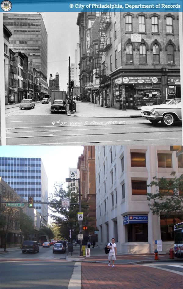 1959-2009
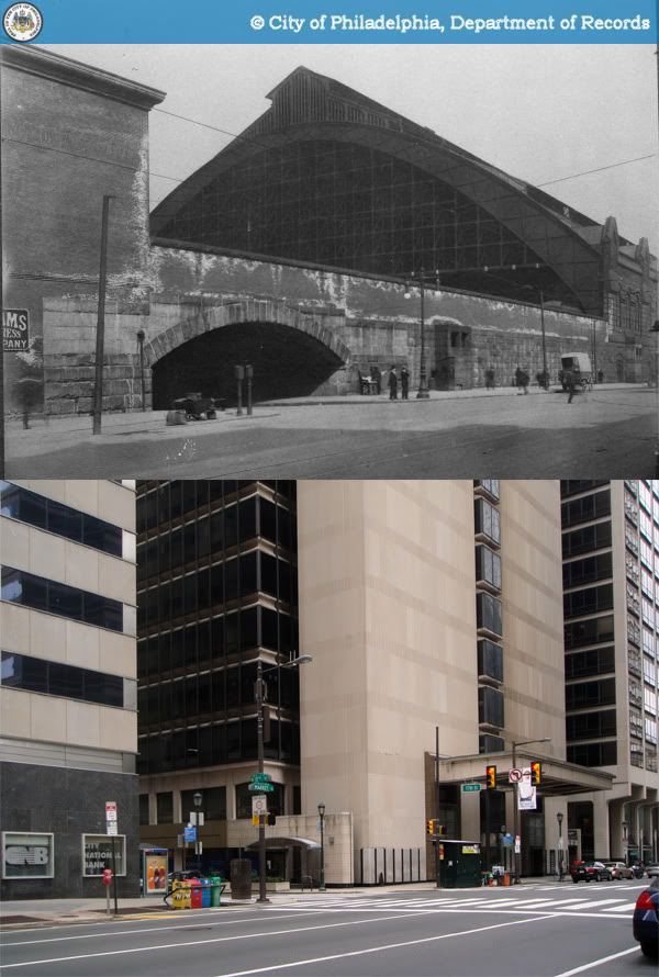


