Monday, July 27, 2009

Then and Now: 11th and Market Streets, Philadelphia

1960-2009

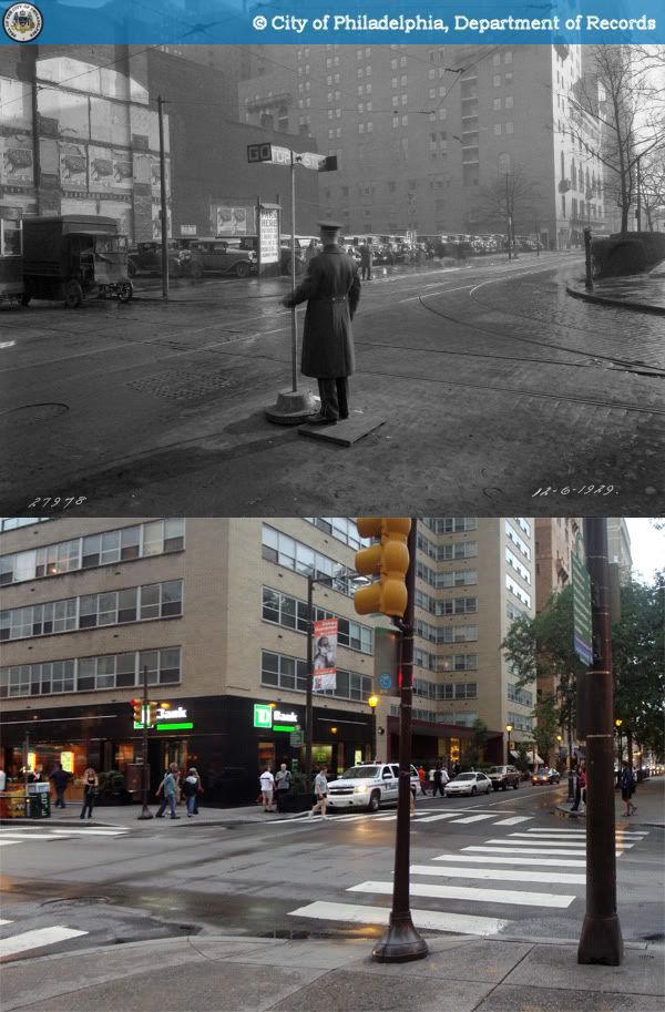
Save for its grandest buildings - the PSFS Building, the Reading Terminal, and Wanamaker's Department Store - little remains of pre-1950 Market Street east of City Hall. Hardly any of it seems to even suggest to unknowing passersby that the half-mile strip known as Market East was once one of the nation's most legendary retail districts, before it falling to neglect, destruction, and ill-conceived urban renewal.

The vacant lot in the original image was what remained of the former Frank & Seder Department Store in 1960. The Denkla Building ("Howard" on the ground floor) and its neighbors went down sometime between then and 1984, when the pink and brown One Reading Center now known as the Aramark Tower was completed. The Gallery at Market East's expansion to 11th street (right side of current view) was completed in the same year.

Sources:
1. "Philadelphia Land Use Map, 1942." Library Company of Philadelphia. Philadelphia Geohistory Network. Athenaeum of Philadelphia. 27 Jul. 2009. http://www.philageohistory.org/rdic-images/view-image.cfm/LUM1942.4B-1
2. Philadelphia Architects and Buildings
3. "Aramark Tower, Philadelphia." Emporis.com. 27 Jul. 2009. http://www.emporis.com/application/?nav=building&id=117916.
Original photo: "Department of Public Property-41263-0." 1960. Philadelphia City Archives. PhillyHistory.org. Philadelphia Department of Records. 27 Jul. 2009. http://www.phillyhistory.org/PhotoArchive/MediaStream.ashx?mediaId=143891

Friday, July 24, 2009

Then and Now: Southeast Corner of 18th and Walnut Streets, Philadelphia

1929-2009

Here's a continuation of the Parking in Prominent Places theme that began two posts ago. In the early 20th century, due to downtown's westward expansion, skyrocketing land values and improved building technology, the old town houses that flanked Rittenhouse Square began to gave way to the luxury high-rise apartments we know today. During that transitional period, the southeast corner of 18th and Walnut, where Philadelphia's most fashionable shopping street meets its most beloved park, spent over two decades as a parking lot. It was finally replaced in 1951 by the Rittenhouse Claridge apartments, an International Style Modernist tower designed by Samuel Oshiver.

It would also be impossible not to note the quaintness of the police officer in the picture manually operating a "traffic light."

Sources: Philadelphia Architecs and Buildings
Original photo: Abuhove, Maurice D. "Public Works-27978-0." 1929. City of Philadelphia Archives. PhillyHistory.org. Philadelphia Department of Records. 23 Jun 2009. http://www.phillyhistory.org/PhotoArchive/MediaStream.ashx?mediaId=21059

Thursday, July 23, 2009

Then and Now: Southeast corner of 36th and Walnut Streets, Philadelphia

1963-2009

Original photo: "Historic Commission-12404-21." 1963. City of Philadelphia Archives. PhillyHistory.org. Philadelphia Department of Records. 19 Jun. 2009.
http://www.phillyhistory.org/PhotoArchive/MediaStream.ashx?mediaId=148293

Monday, July 20, 2009

Then and Now: le plateau Beaubourg, Paris

1957-2009

Up through the 19th century, the plateau Beaubourg, just a short walk from the market stalls of les Halles, was much like any other large swath of working-class Paris - crowded, dense, and miserable, perhaps just a bit more than average. In 1906, when the city began identifying areas in greatest need of renewal (i.e. demolition) the neighborhood, conspicuously located in the center of the city, became known simply as îlot insalubre n°1.

As far as redevelopment processes go, this one was particularly lengthy. After being delayed by World War I and a slow and painful economic recovery, demolition of "Insalubrious Block Number 1" began in the 1930s, just in time for the Great Depression and another World War. With no plans for new construction on the site, the plateau spent the three decades as an enormous surface parking lot in the heart of Paris, as pictured above.

Construction on the Centre Georges-Pompidou and its plaza began in 1971 and was completed six years later, ironically at a time when we in America were busy replacing our own downtowns with parking lots.

Links (in French):
Îlots insalubres parisiens [Wikipedia]
Découvrir l'Architecture du Centre Pompidou [Centre Pompidou]


Original photo: "PARIS - EMPLACEMENT BEAUBOURG." 1957. Collection Roger-Viollet. Parisenimages.fr. Parisienne de Photographie. 17 May 2009. http://www.parisenimages.fr/Export450/1000/664-3.jpg

Sunday, July 19, 2009

Then and Now: 1700 Chestnut Street, Philadelphia

1984-2009

The former Bonwit Teller department store tower went up in 1927, the work of local architect Clarence Edmond Wunder. In the past decade or so since Bonwit Teller closed, the first floor has been occupied by a Daffy's.

Source: Philadelphia Architects and Buildings.
Original photo: Gouldey, Dick. "Historic Commission-22100-10." 1984. Philadelphia City Archives. PhillyHistory.org. Philadelphia Department of Records. 18 Jul. 2009. http://www.phillyhistory.org/PhotoArchive/MediaStream.ashx?mediaId=140331

Thursday, July 16, 2009

Back streets of Dongqu (東區), Taipei

Essentially built from the ground up in the 1970s, Taipei's "East District" (Dongqu - 東區) remains the city's premiere dining, shopping, and nightlife mecca. While its bustling main avenue, Zhongxiao East Road (忠孝東路), is home to its major restaurants and department stores, some of Taipei's best city life is to be found in the district's little side streets and alleyways.

In terms of scale and pace, these streets feel worlds removed from Zhongxiao E. Road. Though packed with shops and businesses, life move a bit more slowly here. Taipei often lays claim to being the most relaxed of Asia's Chinese-speaking metropolises, and nowhere is that more evident than here. At nightfall, once the brutal heat of day disappears, the streets begin to fill with a steady stream of beautiful Taiwanese flâneurs lasting deep into the night.

The neighborhood is home to an incredibly varied retail mix that includes boutiques, restaurants, tea houses, bars, and lounges of all price levels, not to mention the city's ubiquitous food carts. Equally impressive is the proximity and coexistence of multinational mega-retailers and cheap roadside stalls, as pictured above.

Coming from a Western city-dweller's perspective, it might seem amazing that the area has any street-level vibrancy at all. Off of the major avenues, there are just about no sidewalks - narrow streets are shared by cars, scooters, bikes, and pedestrians. It takes sharing the road to a whole new level. But somehow, it all just comes together perfectly. It's hard to find downtown city neighborhoods that feel as lived-in and intimate as these do.

Thursday, July 2, 2009

Then and Now: Arch Street east of 10th Street, Philadelphia

1916-2009

It's often hard to see the potential of neglected buildings before seeing them in their original state. While urban renewal largely flattened Arch Street between 8th and 5th Streets, the 900 block, including these three buildings, and was later spared from redevelopment by the Chinatown area's poor economic status. Sometimes, poverty plays an unexpected role in historic preservation. On the other hand, neglect and unsensitive alterations removed their original storefronts, detailing, and hence, their elegance. If it's any consolation, at least they didn't end up like the other side of the street.

Original photo: Biggard, D. Alonzo. "Department of City Transit-3277-0." 1916. Philadelphia City Archives. PhillyHistory.org. Philadelphia Department of Records. 1 Jul. 2009. http://www.phillyhistory.org/PhotoArchive/MediaStream.ashx?mediaId=29113