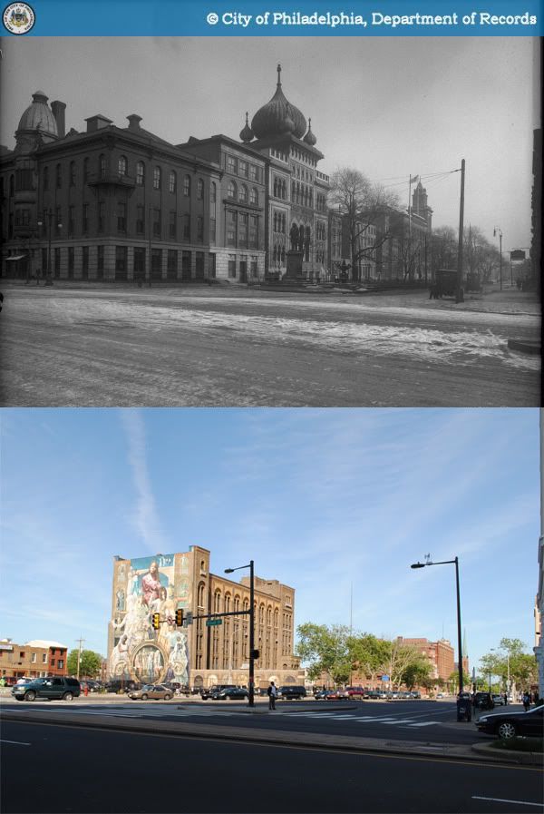
 1916-2010
For many decades, the 1300 block of Spring Garden Street was one of Philadelphia's grandest blocks, anchoring the civic and institutional core of lower North Philadelphia. Six years before the consolidation of Philadelphia County into a single municipality, the Spring Garden District built its Commissioner's Hall at the northwest corner of 13th and Spring Garden Streets in 1848. Three years later, the Spring Garden Institute opened its doors at the other end of the block, at the corner of Broad Street. The Commissioner's Hall was demolished in 1892 and replaced by the Philadelphia Normal School for Girls, whose tower is visible in the original photograph.
The onion-domed building adjacent to the Spring Garden Institute is the city's Lu Lu Temple, built in 1904 for the Shriners fraternal order. The Shriners, an offshoot of the Freemasons, were heavily inspired by Middle Eastern traditions, as evident in the Philadelphia temple's design by architect Frederick Webber.
For reasons I'm not aware of, the two sections of Spring Garden Street separated by Broad Street were originally not aligned at that intersection; the portion east of Broad terminated roughly 70 feet south of the portion west of Broad. As early as the Civil War, the 1200 and 1300 blocks of Spring Garden were also doted with a spacious and pleasant-looking planted median strip. Real estate atlases seem to indicate that the median was removed sometime around 1920 (perhaps for the construction of the Broad Street Subway).
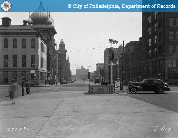 Spring Garden east of Broad in 1941, from the State Office Building side.
In 1969, the Spring Garden Institute relocated a new campus in Chestnut Hill, abandoning its original site on Broad Street. Its original buildings, along with the substantially decayed Lu Lu Temple, were demolished in 1972, paving the way for the realigned intersection that stands today.
The only building lucky enough to have survived to this day on the 1301 block of Spring Garden Street is the Philadelphia School District's Stevens Administrative Center, built in 1927.
Sources:
1. Bromley, George W. and Walter S. Atlas of the City of Philadelphia, 1910. G. W. Bromley & Co., 1910. http://www.philageohistory.org/rdic-images/view-image.cfm/BRM1910.Phila.001.TitlePage.
2. Calhoun, Chris. "140 Years - A history of practical education." 16 May 2009. Spring Garden College. http://springgardencollege.net/?page_id=12.
3. Khalidi, Omar. "Fantasy, Faith, And Fraternity: American Architecture of Moorish Inspiration." ArchNet. 2004. http://archnet.org/library/documents/one-document.jsp?document_id=9341
Photographs:
1. Biggard, D. Alonzo. "Public Works-37789-0."1941. Philadelphia City Archives. PhillyHistory.org. Philadelphia Department of Records. 21 Jun. 2010. http://www.phillyhistory.org/PhotoArchive/MediaStream.ashx?mediaId=21485.
2. "Public Works-11638-0." 1916. Philadelphia City Archives. PhillyHistory.org. Philadelphia Department of Records. 21 Jun. 2010. http://www.phillyhistory.org/PhotoArchive/MediaStream.ashx?mediaId=19747.
 c. 2000-2010
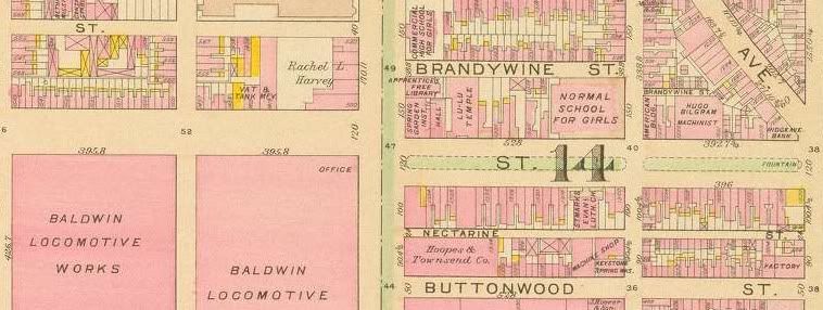


