Monday, May 31, 2010
Then and Now: Northwest corner of 8th and Sansom Streets, Philadelphia
Up through the end of the First World War, this corner of Jewelers' Row conserved much of its late Victorian era appearance. Since then, through a series of alterations, the short block has lost many of its original façades and some of its former density. The building with the six-story tower on the far right of the original photo is the Times Building, built for the Times publishing company in the late 1870s and demolished roughly a century later.
Source: Philadelphia Architects and Buildings
Original photo: Mills, Charles P. "Department of City Transit-3829-0." 1917. Philadelphia City Archives. PhillyHistory.org. Philadelphia Department of Records. 5 Apr. 2010. http://www.phillyhistory.org/PhotoArchive/MediaStream.ashx?mediaId=38533.
Friday, May 28, 2010
Then and Now: 9-15 East Athens Avenue, Ardmore
In the fight against brick, stucco wins a small victory at Ardmore's Walton Apartments. Not much seems to be known about this humble apartment block, built in the early 1920s. Apparently, those in charge of the building's rehab have decided to replace only the top portion of the brick exterior, while leaving the rest intact (hopefully I'm not mistaken!).
Source: Lower Merion Atlases
Original photo: "9-15 E Athens Ave." Lower Merion/Narberth Buildings. Lowermerionhistory.org. Lower Merion Historical Society. 9 May 2010. http://lowermerionhistory.org/buildings/image-building-list.php?photo_id=6885.
Source: Lower Merion Atlases
Original photo: "9-15 E Athens Ave." Lower Merion/Narberth Buildings. Lowermerionhistory.org. Lower Merion Historical Society. 9 May 2010. http://lowermerionhistory.org/buildings/image-building-list.php?photo_id=6885.
Monday, May 24, 2010
Then and Now: 818-820 Chestnut Street, Philadelphia
Though not quite obvious from its current appearance, this vacant storefront on a quiet block of Chestnut Street gave birth to a true icon of 20th century American dining. In 1902 the Horn & Hardart Baking Company opened their first automat on the ground floor of the Pierson Building at 818-820 Chestnut Street. The automat, where diners purchased food and drink entirely from coin-operated machines, was the first of its kind in the United States. Horn & Hardart expanded rapidly in the decades that followed, developing a legendary presence in Philadelphia and New York before falling into obscurity at the end of the century.
The original Chestnut Street automat was enlarged and renovated during the 1930s, with design work done by architect Ralph Bowden Bencker. During the 20s and 30s, Bencker completed over thirty commissions for Horn & Hardart stores and offices, most of them in Philadelphia. After the original automat shut its doors in the late 1960s, the location operated for some time as a pharmacy. Although the original metalwork has been painted over, the exterior façade appears to be intact, save for the doorway. I've never gone through an exhaustive list of Horn & Hardart's former locations, but it's safe to say that this is certainly one of extremely few preserved storefronts of theirs left in Philadelphia.
Meet me at the automat [Smithsonian magazine]
Source: Philadelphia Architects and Buildings
Original photo: "Historic Commission-12210-48." 1963. Philadelphia City Archives. PhillyHistory.org. Philadelphia Department of Records. 4 Apr. 2010. http://www.phillyhistory.org/PhotoArchive/MediaStream.ashx?mediaId=114811.
Thursday, May 20, 2010
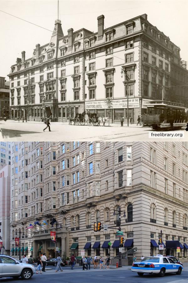
Then and Now: Southwest corner of Broad and Walnut Streets, Philadelphia
The Stratford Hotel, originally named the Hotel St. George, was built sometime between 1875 and 1885 at the southwest corner of Broad and Walnut Streets. Eventually, the Stratford was acquired by the Hotel Bellevue, a highly successful establishment run by George C. Boldt, located directly across Walnut Street. In 1902, the Stratford Hotel was demolished to make way for Boldt's crowning achievement, the Bellevue-Stratford Hotel, a luxurious 20-story Beaux-Arts tower designed by G. W. and W. D. Hewitt, former partners of Frank Furness.
The dramatic differences between the Bellevue-Stratford and its predecessor of two decades, the Stratford, reflect the astonishing growth of Philadelphia at the turn of the century and the ambition and decadence of that era. Despite numerous additions and alterations made since its initial construction, the Bellevue (as it's now called) retains much of its original character, and remains one of South Broad Street's most significant landmarks.
Sources:
1. Bromley, George W. and Walter S. Atlas of the City of Philadelphia, 1885. Philadelphia: G. W. Bromley & Co, 1885. http://philageohistory.org/geohistory/index.cfm.
2. Hopkins, G. M. City Atlas of Philadelphia, Vol. 6, Wards 2 through 20, 29 and 31. Philadelphia: G. M. Hopkins, C. E., 1875. http://philageohistory.org/geohistory/index.cfm.
3. Thomas, George E. "National Register of Historic Places Inventory - Nomination Form: Bellevue Stratford Hotel." 1976. National Park Service. United States Department of the Interior. 20 May 2010. http://www.arch.state.pa.us/pdfs/H001328_01B.pdf.
Original photo: Jennings, W.K. "PDCL00172." Free Library - Historical Images of Philadelphia. PhillyHistory.org. Philadelphia Department of Records. 19 May 2010. http://www.phillyhistory.org/PhotoArchive/MediaStream.ashx?mediaId=166757.
Sunday, May 16, 2010
Then and Now: Corner of 32nd and Market Streets looking northeast, Philadelphia
At the time of the Second World War, the Market-Frankford Line was fully elevated through West Philadelphia, emerging from the subway tunnel at 22nd and Market Streets. The original photograph shows part of the original "El" station at 32nd Street, completed in 1908. Barely visible in the background of the original photo is the Pennsylvania Railroad's West Philadelphia Station, which at the time was the city's main railroad station west of the Schuylkill River. West Philadelphia Station was demolished after the opening of 30th Street Station in 1933.
During the war, the City of Philadelphia and the Philadelphia Transit Company (PTC) initiated a major project to extend the Market Street subway tunnel from 22nd Street past 40th Street. Furthermore, the PTC's West Philadelphia trolley lines would be rerouted into a subway tunnel below Woodland Avenue, joining the Market Street Subway tunnel at 32nd Street. Due to the relocation of the Pennsylvania Railroad station to 30th Street, the new Market-Frankford Line stations were built at 30th and 34th Streets, neither of which were previously station stops. The transit tunnels opened in 1955, and the obsolete elevated rails and stations were removed the following year.
About a decade ago, Drexel University annexed the block of 32nd Street between Market and Chestnut Streets, and has since developed it into a landscaped pedestrian walkway.
Market-Frankford Line [nycsubway]
Source: Darlington, Peggy, Gregory Jordan-Detamore, and David Pirmann. "Market-Frankford El." world.nycsubway.org. 12 May 2010. http://world.nycsubway.org/us/phila/market-frankford.html.
Original photo: Quinn. "Department of City Transit-20601-0." 1930. Philadelphia City Archives. PhillyHistory.org. Philadelphia Department of Records. 12 May 2010. http://www.phillyhistory.org/PhotoArchive/MediaStream.ashx?mediaId=19505.
Thursday, May 13, 2010
Then and Now: Market Street west of 11th Street, Philadelphia
Originally located at the corner of 5th and South Streets, the N. Snellenberg & Co. department store moved to Market East at the turn of the 20th century. At its height, the Snellenberg's department store occupied a full block of Market Street between 11th and 12th Streets, across from Reading Terminal.
Snellenberg's was one of the earliest of Market East's large department stores to collapse, going out of business in 1963. Although the Community College of Philadelphia opened in 1965 in the mens department annex at 34 South 11th Street, the Market Street buildings remained vacant. To cut down on maintenance costs, the Girard Estate, which has owned the property since the early 19th century, removed all but the bottom two stories of the six-story buildings, unifying their facades under a modernist exterior.
Source: Warner, Susan. "What's in store in Center City?" Philadelphia Inquirer. 26 Apr. 1999: F01.
Original photo: Carollo, R. "Historic Commission-2648-1." 1965. Philadelphia City Archives. PhillyHistory.org. Philadelphia Department of Records. 10 May 2010. http://www.phillyhistory.org/PhotoArchive/MediaStream.ashx?mediaId=106691.
Tuesday, May 11, 2010
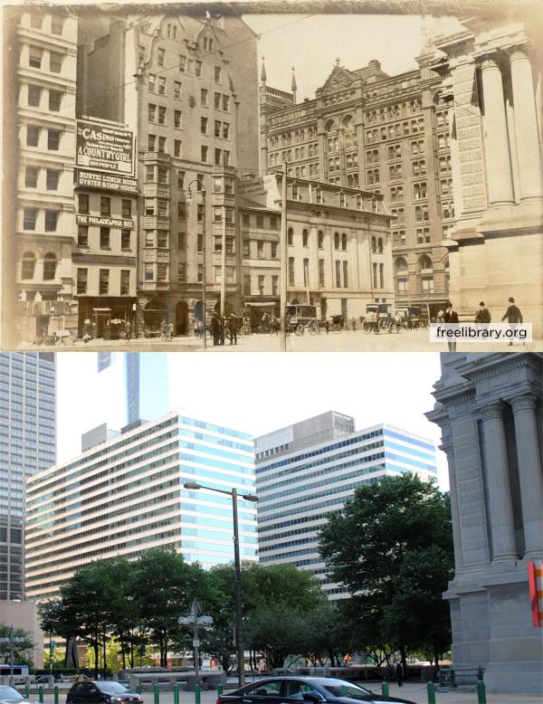
Then and Now: West side of Penn Square, Philadelphia
For the first half of the 20th century, Broad Street veered off of its linear path at City Hall, snaking around the west side of the public buildings on what could otherwise have been called "West Penn Square." A decade after the original photograph was taken, the four buildings facing Broad Street from the left edge of the photo had been demolished to make way for the Commercial Trust Building (aka Arcade Building), a behemoth structure occupying nearly the entire block bounded by 15th St., Broad St., Market St., and South Penn Square.
After the demolition of Broad Street Station in 1953, the Planning Commission envisioned an extension of City Hall's plaza from Broad Street to 15th Street. Two and Three Penn Center, the twin office buildings featured prominently in today's view, were built west of 15th Street. The Arcade Building was not demolished until 1969, paving the way for a concrete plaza and subterranean transit concourse completed in 1977, now known as Dilworth Plaza. If the Center City District has its way, the oft-maligned public space may receive a dramatic makeover in the next few years.
Center City Reports: Transforming Dilworth Plaza [Center City District]
Source: Philadelphia Architects and Buildings
Original photographs:
1. "PDCL00160." 1903. Free Library of Philadelphia - Historical Images of Philadelphia. PhillyHistory.org. Philadelphia Department of Records. 10 May 2010. http://www.phillyhistory.org/PhotoArchive/MediaStream.ashx?mediaId=166729.
2. Boucher, Jack. "PA-1493-1 - General view, from east." 1962. Historic American Buildings Survey. Library of Congress. 10 May 2010. http://memory.loc.gov/pnp/habshaer/pa/pa1000/pa1083/photos/139988pv.jpg.
Sunday, May 9, 2010
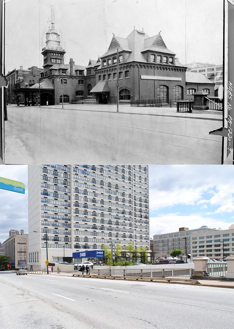
Then and Now: Baltimore & Ohio Railroad station, 24th and Chestnut Streets, Philadelphia
The Baltimore & Ohio Railroad entered Philadelphia's rapidly-growing passenger rail market in the late-19th century, opening its own passenger terminal in 1888 at 24th and Chestnut Streets, at the foot of the Chestnut Street Bridge. The station was designed by none other than the prolific Furness, Evans, & Co., who went on the build the much grander expansion to Broad Street Station just a few years later. Perhaps owing to the station's less than ideal location and relatively minuscule size, it never quite achieved the landmark status attained by the city's other two Center City terminals, Broad Street Station and Reading Terminal.
Passenger service ended along the Baltimore & Ohio line in the late 1950s, and the Philadelphia station was demolished in 1963. The building's former site stood vacant for over a decade before the completion of a 34-story apartment tower, 2400 Chestnut, in 1979. Through a number of acquisitions and mergers, the remnants of the B&O are now part of CSX Transportation, a freight company which continues to operate the railroad's tracks along the Schuylkill.
Some more tidbits on 2400 Chestnut [Philly Skyline]
Sources:
1. "2400 Chestnut Apartments, Philadelphia, U.S.A." Emporis.com. 8 May 2010. http://www.emporis.com/application/?nav=building&lng=3&id=2400chestnutapartments-philadelphia-pa-usa.
2. Philadelphia Architects and Buildings
Original photos:
1. "PA-1220-7 - Photocopy of photograph: Perspective view of north and east elevations." Historic American Buildings Survey. American Memory. Library of Congress. 8 May 2010. http://memory.loc.gov/pnp/habshaer/pa/pa1000/pa1097/photos/138632pv.jpg.
2. "PA-1220-9 - View from north west, closeup of station." Historic American Buildings Survey. American Memory. Library of Congress. 8 May 2010. http://memory.loc.gov/pnp/habshaer/pa/pa1000/pa1097/photos/138634pv.jpg.
Tuesday, May 4, 2010
Then and Now: East bank of Schuylkill River from Chestnut Street Bridge, Philadelphia
In 1928, the lower end of the Schuylkill River running through Center City Philadelphia was not exactly an inviting place to linger. Between Spring Garden Street and Spruce Street, the river's east bank was lined with freight depots, warehouses, and factories, while the west bank was home to an enormous stockyard and abbattoir. To top it off, much of the city's untreated sewage was dumped directly into the river via over twenty mains placed by the Fairmount Dam, turning the Schuylkill into an enormous cesspool.
As the 20th century progressed, the lower Schuylkill slowly shed its grimy, industrial character. The current Market Street Bridge replaced its iron predecessor in 1932. Shortly afterward, the west bank was wholly transformed after the stockyards were replaced by 30th Street Station and the adjacent U.S. Post Office. In the 1950s and 1960s, the city made great strides toward completing its sewage treatment network, vastly improving the river's water quality. One by one, the freight yards and warehouses along the east bank closed under the forces of deindustrialization. The Hudson Essex automobile factory (pictured above) shut its doors, reopening as the Marketplace Design Center, a design showroom, in 1975.
Forward-looking Philadelphians had in fact dreamed of a riverfront park on the lower Schuylkill's east bank as early as the 1920s. Concrete development plans emerged for the first time in the late 1960s, but came to a grinding halt before being revived nearly 30 years later. In 1995, the City of Philadelphia began finally began construction of a segment of the Schuylkill River Trail between Kelly Drive and Locust Street. Originally scheduled for completion in 1997, spectacular delays and legal battles postponed the park's official opening to 2004.
Sources:
1. Demick, Barbara. "The Marketplace: its doors open by invitation only." Philadelphia Inquirer. 11 Jul. 1988: D01.
2. Heavens, Alan J. "Schuylkill Park ready to bloom." Philadelphia Inquirer. 4 Jun. 1995: R01.
3. Lewis, John Frederick. The Redemption of the Lower Schuylkill. Philadelphia: The City Park Association, 1924.
4. Saffron, Inga. "A fine park now, and even better later - the Schuylkill parks' present, promise." Philadelphia Inquirer. 25 Jun. 2004: E01.
Original photo: "CPA1146 - East bank of the Schuylkill from Chestnut Street Bridge." 1928. City Parks Association Photographs. Temple University Libraries, Urban Archives. 1 May 2010. http://digital.library.temple.edu/u?/p15037coll5,208.
Saturday, May 1, 2010
Then and Now: Southwest corner of 10th and Arch Streets, Philadelphia
While the altered facades on the two corner buildings pictured are lamentable, one should perhaps be grateful that they are still standing at all. On May 3, 1984, flames broke out during renovation work for the Harrison Court building at 10th and Filbert (bottom left of original photo). Miraculously, only two people were treated for injuries from the conflagration. The fire however, largely destroyed the 1000 block of Filbert Street, inadvertently clearing the way for what is now the city's Greyhound bus terminal.
Gibbons, Thomas J., L. Stuart Ditzen, and Hank Klibanoff. "9-alarm fire hits Center City - 18 buildings burn." Philadelphia Inquirer. 4 May 1984: A01.
Subscribe to:
Comments (Atom)


