Saturday, August 15, 2009
Then and Now: 11th and Market Streets looking west, Philadelphia
Nothing quite looks the same on the 1100 block of Market Street. Snellenburg's is gone, The Gallery II is now across the street, and the streetscape has gotten new lights, paving, planters, trees, newspaper boxes and stands, trash cans, bus shelters, and even a reconfigured subway stop. It's a nice surprise then to see the streetcar pole for the former Route 23 trolley standing right where it's always been.
Original photo: Balionis, Francis. "Public Works-41807-6." 1952. Philadelphia City Archives. PhillyHistory.org. Philadelphia Department of Records. 8 Aug. 2009. http://www.phillyhistory.org/PhotoArchive/MediaStream.ashx?mediaId=33365
Tuesday, August 11, 2009
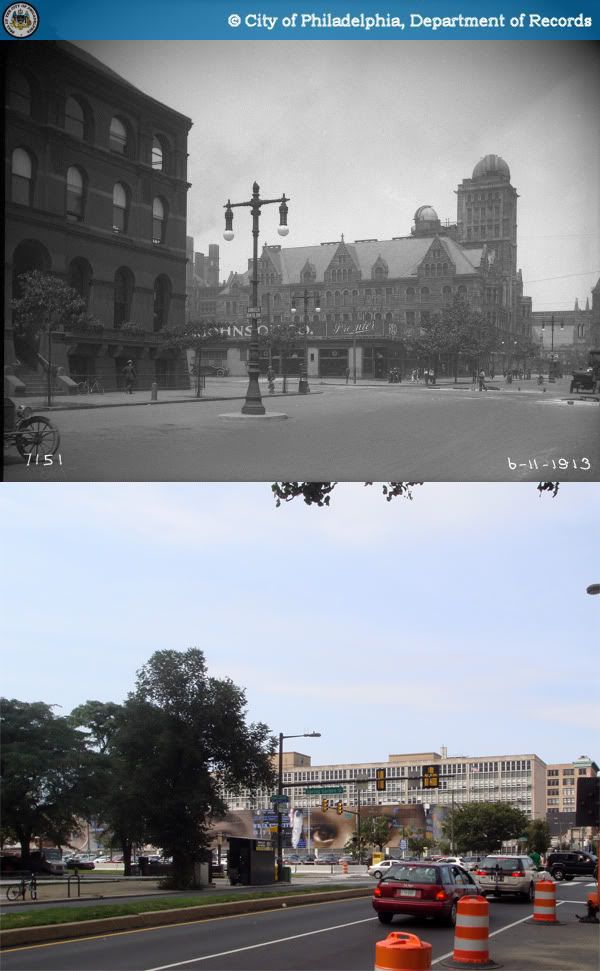
Then and Now: Broad and Spring Garden Streets looking North, Philadelphia
1913-2009The southwest corner of Broad and Spring Garden (photo left) had become a gas station by the early 40s, before being replaced in 1958 by the State Office Building and plaza. Central High School on the center right (which will hopefully have its own post soon) was succeeded by the decidedly less inspiring Benjamin Franklin High School, also completed in 1958.
Sources:
1. Philadelphia Architects and Buildings
2. "Philadelphia Land Use Map, 1942." Library Company of Philadelphia. Philadelphia Geohistory Network. Athenaeum of Philadelphia.
Original Photo: "Public Works-7151-0." 1913. Philadelphia City Archives. PhillyHistory.org. Philadelphia Department of Records. 6 Aug. 2009. http://www.phillyhistory.org/PhotoArchive/MediaStream.ashx?mediaId=19917
Sources:
1. Philadelphia Architects and Buildings
2. "Philadelphia Land Use Map, 1942." Library Company of Philadelphia. Philadelphia Geohistory Network. Athenaeum of Philadelphia.
Original Photo: "Public Works-7151-0." 1913. Philadelphia City Archives. PhillyHistory.org. Philadelphia Department of Records. 6 Aug. 2009. http://www.phillyhistory.org/PhotoArchive/MediaStream.ashx?mediaId=19917
Sunday, August 9, 2009
Everything wrong with Independence Mall, Philadelphia
What the folks at the Independence Visitors' Center won't tell you is that the heart of Philadelphia's "most historic square mile" is ironically also the worst preserved section of the city's downtown. Shortly after the National Park Service's creation of Independence National Historic Park around Old City and Independence Hall in 1948 (which involved its own destruction of old but not "historic" buildings) Philadelphia megaplanner Ed Bacon and associated Planning Commission began to devise what would be their worst plan ever implemented.
Very much a modern apparition of City Beautiful planning, the vision of Independence Mall was to create a new axis north of Independence Hall by widening 5th and 6th Streets between Chestnut and Race Streets, replacing everything in between 5th and 6th with parkland, and lining it all with new corporate and civic buildings of uniform massing. There was apparently no perceived shame or contradiction in demolishing several fine-grained, 19th century, uniquely Philadelphian downtown blocks to extend a historic park ("it ain't historic unless it's red brick colonial!")
Even more depressing is how incredibly lackluster its replacement is. To begin with, the immense scale of the Mall acts as a significant barrier to pedestrian connectivity between Market East and Old City. Save for the Rohm & Haas headquarters, 5th and 6th Streets along the Mall are home to the city's most uninspiring Modernist architecture, with absolutely atrocious sidewalk presence. The terrible urban design here creates an incredible deadening effect on a three-block stretch between 4th and 7th Streets, decimating any form of street life.
Very much a modern apparition of City Beautiful planning, the vision of Independence Mall was to create a new axis north of Independence Hall by widening 5th and 6th Streets between Chestnut and Race Streets, replacing everything in between 5th and 6th with parkland, and lining it all with new corporate and civic buildings of uniform massing. There was apparently no perceived shame or contradiction in demolishing several fine-grained, 19th century, uniquely Philadelphian downtown blocks to extend a historic park ("it ain't historic unless it's red brick colonial!")The Mall never generated the kind of visitor traffic used by planners to justify the project, and the National Park Service recently finished a complete re-landscaping of the Mall's open space in an effort to increase visitation. Neither is it much of an amenity to local residents, as there is nary a Philadelphian who volunteers to spend his or her free time here. None of this is really unexpected if one believes that parks are only as vibrant as their immediate surroundings.
It's simply a travesty that Independence Mall, the city's premier tourist site just steps away from the symbolic birthplace of American democracy, is such a terribly boring place with no visible history to speak of. Yes, these are harsh words, but I'm certain that these thoughts will ring true to many others.The famous Chicago planner Daniel Burnham is often remembered for the statement, "Make no small plans; they have no magic to stir men's blood." But we would do just as well to keep in mind that big plans can easily become big mistakes.
Photo credit:
1. Gehr, Herbert. "Independence Hall Philadelphia." LIFE Photo Archive. Google Images. 9 Aug. 2009. http://www.gstatic.com/hostedimg/3a8466011e8effa8_large
2. Independence National Historic Park. "Independence Mall, 1979." Greater Philadelphia Tourism Marketing Corporation. Gophila.com. 9 Aug. 2009. http://press.gophila.com/media/1112
Friday, August 7, 2009
Then and Now: Philadelphia main post office, 30th and Market Street, Philadelphia
Alongside 30th Street Station just across Market Street, Philadelphia's former main post office is one of the city's most imposing civic buildings. Its architects, Rankin & Kellogg, were also responsible for many of the city's most iconic early 20th century buildings, including the Architects' Building, the Inquirer Building. and the Provident Trust Company tower. The structure was also a substantial engineering feat, built on a platform above 30th Street Station's railroad tracks in 1935.
Unfortunately, I never had the pleasure of seeing its grand interior before the post office closed several years ago, and presumably never will. The building is currently being renovated for the Internal Revenue Service's new Philadelphia office, as part of the University of Pennsylvania and Brandywine Realty Trust's Cira Centre South project. The former 30th Street loading docks slightly visible in the photo are set to be converted to an outdoor terrace for IRS workers. The Bolt Buses will probably have to load somewhere else once that happens.
Cira Centre South [Skyscraperpage]
Original photo: Wenzell J. Hess, "Public Works-41057-0-C." 1950. Philadelphia City Archives. PhillyHistory.org. Philadelphia Department of Records. http://www.phillyhistory.org/PhotoArchive/MediaStream.ashx?mediaId=68115
Wednesday, August 5, 2009
Then and Now: 2138 Market Street, Philadelphia
Though the Salvation Army does lots of good, charitable deeds, I can't quite say as much about their building preservation savvy. It's sad to see perfectly good tall shop windows go to waste under an ugly layer of stucco, not to mention the awful aluminum mansard roof imitation.
Original photo: Cuneo. "Department of City Transit-29897-0." 1953. Philadelphia City Archives. PhillyHistory.org. Philadelphia Department of Records. 3 Aug. 2009. http://www.phillyhistory.org/PhotoArchive/MediaStream.ashx?mediaId=51097
Monday, August 3, 2009
What's in a bus stop?
Here in Philadelphia, SEPTA runs a very extensive bus network that (at least on weekdays) provides good and frequent service on most city routes. This is probably one of the city's most well-guarded secrets. For just about anyone who's never needed to get somewhere by bus, the whole thing's an enormous, inscrutable mystery. In many ways, it comes down to a simple problem of signage.
SEPTA's bus stops aren't actually invisible, but to transit newbies, they might as well be. The vast majority of their stops are marked by small signs attached to light or power poles, easily lost among other messy streetscape elements. But that's really the least of our problems. The signs themselves provide minimal descriptions of route endpoints and major roads taken, but even if one is familiar enough with the city's geography to know where those are, most routes tend to wind around quite a bit, so it's really not saying very much. There's a customer service number you could call, or you could wait for the bus and ask the driver, but who really wants to bother with that?
Of course it doesn't need to be this way. There are lots of transit agencies out there that have their bus stops very well thought out, perhaps none more so than Paris. Each stop with a bus shelter (most of them) is equipped with route maps, system maps, a neighborhood map, and a nifty electronic screen that displays waiting times for each route.


Unfortunately, this costs a lot of money, something which SEPTA and most US transit agencies have historically been short on. But an effective and informative system can still be devised on a more restricted budget. For an indication of how much information can be packed into small signs, Taipei provides a sharp example. Each bus signpost has a basic map listing all stops, transfers to rail services, off-peak and peak hour frequencies, and first and last bus times.
It's already miles ahead of what SEPTA provides - to get any of that kind of information most of us just have to spend our time fumbling through route maps online or in stations. Attracting more people to transit is one of the most important challenges of the 21st century, and all forms of transit should be made as easily navigable as possible to draw new ridership. The biggest hurdle in learning a bus system is finding bus stops, routes, and where they connect. Unfortunately, SEPTA makes this about as hard as it could be. Putting aside notions of social stigma that surrounds taking the bus, is it any wonder that buses have few casual riders given how inaccessible the system is? If SEPTA really wants to be a world class transit network the city deserves, this isn't going to cut it anymore.
SEPTA's bus stops aren't actually invisible, but to transit newbies, they might as well be. The vast majority of their stops are marked by small signs attached to light or power poles, easily lost among other messy streetscape elements. But that's really the least of our problems. The signs themselves provide minimal descriptions of route endpoints and major roads taken, but even if one is familiar enough with the city's geography to know where those are, most routes tend to wind around quite a bit, so it's really not saying very much. There's a customer service number you could call, or you could wait for the bus and ask the driver, but who really wants to bother with that?
Of course it doesn't need to be this way. There are lots of transit agencies out there that have their bus stops very well thought out, perhaps none more so than Paris. Each stop with a bus shelter (most of them) is equipped with route maps, system maps, a neighborhood map, and a nifty electronic screen that displays waiting times for each route.

Unfortunately, this costs a lot of money, something which SEPTA and most US transit agencies have historically been short on. But an effective and informative system can still be devised on a more restricted budget. For an indication of how much information can be packed into small signs, Taipei provides a sharp example. Each bus signpost has a basic map listing all stops, transfers to rail services, off-peak and peak hour frequencies, and first and last bus times.
It's already miles ahead of what SEPTA provides - to get any of that kind of information most of us just have to spend our time fumbling through route maps online or in stations. Attracting more people to transit is one of the most important challenges of the 21st century, and all forms of transit should be made as easily navigable as possible to draw new ridership. The biggest hurdle in learning a bus system is finding bus stops, routes, and where they connect. Unfortunately, SEPTA makes this about as hard as it could be. Putting aside notions of social stigma that surrounds taking the bus, is it any wonder that buses have few casual riders given how inaccessible the system is? If SEPTA really wants to be a world class transit network the city deserves, this isn't going to cut it anymore.
Saturday, August 1, 2009
Then and Now: 1201 Block of Market Street, Philadelphia
The entire block between 12th, 13th, Market, and Filbert Streets disappeared sometime around 1990, replaced by an enormous 1200-room Marriott in 1995 as part of the massive redevelopment project that created the Pennsylvania Convention Center and transformed the upper end of Market East. As far as massive buildings go, the Marriott's design isn't bad. Unlike certain very underperforming 1-story blocks to the east, its density and massing is appropriate for its downtown location near major transportation hubs, and its retail spaces provide good sidewalk presence.
Nonetheless, the Marriott conserves none of the original urban "texture" of Market East. The building sits on a superblock that was formerly made up of 31 individual building lots, with just as many buildings serving a variety of functions (see Land Use Map below). Unfortunately, no matter how well designed, one building simply can't be as interesting as 31. The consolidation of building lots and the accompanying loss of diversity of uses that repeated itself all along Market Street to catastrophic results. That one of the country's most fine-grained collections of gilded age commercial architecture was reduced to an unexceptional, banal streetscape is one of Philadelphia's greatest tragedies.
Source: "Philadelphia Land Use Map, 1962." Free Library of Philadelphia Map Collection. Philadelphia Geohistory Network. Athenaeum of Philadelphia. 31 Jul. 2009. http://www.philageohistory.org/rdic-images/view-image.cfm/LUM1962.4B-1
Original Photo: Blanck. "Department of Public Property-41264-0." 1960. Philadelphia City Archives. PhillyHistory.org. Philadelphia Department of Records. 31 Jul. 2009. http://www.phillyhistory.org/PhotoArchive/MediaStream.ashx?mediaId=143893
Subscribe to:
Posts (Atom)